IMAGES TAKEN NEAR TO
John Fulkes Avenue, THAME, OX9 3DN
Introduction
This page details the photographs taken nearby to John Fulkes Avenue, OX9 3DN by members of the Geograph project.
The Geograph project started in 2005 with the aim of publishing, organising and preserving representative images for every square kilometre of Great Britain, Ireland and the Isle of Man.

There are currently over 7.5m images from over14,400 individuals and you can help contribute to the project by visiting https://www.geograph.org.uk
Image Map
Images are licensed for reuse under creativecommons.org/licenses/by-sa/2.0
Notes
- Clicking on the map will re-center to the selected point.
- The higher the marker number, the further away the image location is from the centre of the postcode.
Image Listing (19 Images Found)
Images are licensed for reuse under creativecommons.org/licenses/by-sa/2.0
Image
Details
Distance
1
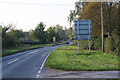
Thame Park Road, Thame
This is where it leaves Thame just past Wenman Road. The road is just as commonly referred to as "the Postcombe road".
Image: © Bill Boaden
Taken: 22 Oct 2011
0.13 miles
2
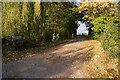
The driveway to Park Meadow Farm
A turning off the B4012.
Image: © Bill Boaden
Taken: 22 Oct 2011
0.15 miles
3
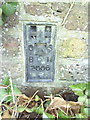
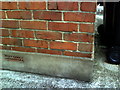
Benchmark bracket serial number 2006 on bridge on Thame Park Road
Ordnance Survey flush bracket benchmark described on the Bench Mark Database at http://www.bench-marks.org.uk/bm1715
Image: © Roger Templeman
Taken: 3 Nov 2010
0.18 miles
4
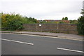
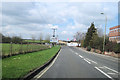
Western parapet of bridge on Thame Park Road
The bridge takes the road over the former railway line near Thame Station. The trackbed is now a Sustrans cycleway. There is an OS flush bracket benchmark Image behind the ivy at the far end of the parapet
Image: © Roger Templeman
Taken: 8 Oct 2013
0.18 miles
5
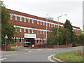
Factory in Thame
This is the Kidde Products factory in Thame Park Road. There is an area of light industry right on the edge of town, south of this there is open country and Thame Park.
Image: © David Hawgood
Taken: 16 Aug 2005
0.18 miles
6

Frosty Field by Wenman Road
On the outskirts of Thame.
Image: © David Lally
Taken: 27 Jan 2009
0.19 miles
7
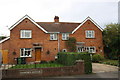
#45 and #47 Hampden Avenue
There is (was) an OS benchmark Image on the left hand house which may be lost to the building of the garage extension
Image: © Roger Templeman
Taken: 8 Oct 2013
0.19 miles
8
Benchmark on #45 Hampden Avenue
Ordnance Survey cut mark benchmark described on the Bench Mark Database at http://www.bench-marks.org.uk/bm35543
Image: © Roger Templeman
Taken: 15 Sep 2010
0.19 miles
10
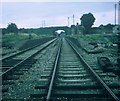
Remains of Thame Railway Station, Oxon
Situated in Thame Park Road, this station was on the railway line between Princes Risborough and Oxford, which closed to passengers in January, 1963. However, the track remained between Princes Risborough and Thame until the mid-1990s. It has now been converted into a cycle trail, whilst the station area is now an industrial estate, its postcode being OX9 3UH.
Image: © David Hillas
Taken: 1 Sep 1969
0.20 miles