IMAGES TAKEN NEAR TO
Roundhead Drive, THAME, OX9 3DJ
Introduction
This page details the photographs taken nearby to Roundhead Drive, OX9 3DJ by members of the Geograph project.
The Geograph project started in 2005 with the aim of publishing, organising and preserving representative images for every square kilometre of Great Britain, Ireland and the Isle of Man.

There are currently over 7.5m images from over14,400 individuals and you can help contribute to the project by visiting https://www.geograph.org.uk
Image Map
Images are licensed for reuse under creativecommons.org/licenses/by-sa/2.0
Notes
- Clicking on the map will re-center to the selected point.
- The higher the marker number, the further away the image location is from the centre of the postcode.
Image Listing (39 Images Found)
Images are licensed for reuse under creativecommons.org/licenses/by-sa/2.0
Image
Details
Distance
1
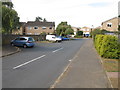
Roundhead Drive, Thame
From junction with Cromwell Avenue.
Image: © David Hawgood
Taken: 23 Sep 2014
0.09 miles
2
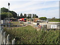
Short Path to the Sewage Works
The start of a very short public footpath over a small field to the gate to a sewage works by the trees in the background.
Image: © Des Blenkinsopp
Taken: 23 Jan 2019
0.09 miles
3
Cromwell Avenue, Thame
From junction with Roundhead Drive.
Image: © David Hawgood
Taken: 23 Sep 2014
0.10 miles
4
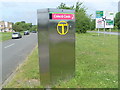
Phone Kiosk on the Thame By-Pass
This KX300 phone kiosk is located on the A4129 Thame By-Pass near Edgehill, a cul-de-sac which can be seen on the left of the photo, its postcode being OX9 3TZ. The T symbol dates back to the 1980s before it was replaced by the Peter Pan logo. Update: the telephone kiosk has since been removed from this location.
Image: © David Hillas
Taken: 2 Jun 2010
0.10 miles
5
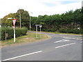
Cromwell Avenue junction with A4129, Thame
The road beyond is the A4129 Tythrop Way which is part of a bypass round Thame.
Image: © David Hawgood
Taken: 23 Sep 2014
0.11 miles
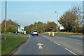
6

Tythrop Way at the junction of Cromwell Avenue
Image: © David Howard
Taken: 10 Oct 2021
0.12 miles
7
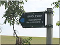
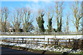
Sign: Bridleway, Haddenham via footpath 2
One route from here is a bridleway within Oxfordshire, then becomes a public footpath in Buckinghamshire. Another starts as a bridleway in Oxfordshire, then diverts onto a public footpath - which becomes a bridleway in Buckinghamshire.
Image: © David Hawgood
Taken: 23 Sep 2014
0.12 miles
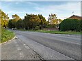
9
A4129 Tythrop Way, Thame
Bypassing the town to the east and north.
Image: © Robin Webster
Taken: 20 Oct 2018
0.14 miles