IMAGES TAKEN NEAR TO
Worton Road, CHIPPING NORTON, OX7 7EG
Introduction
This page details the photographs taken nearby to Worton Road, OX7 7EG by members of the Geograph project.
The Geograph project started in 2005 with the aim of publishing, organising and preserving representative images for every square kilometre of Great Britain, Ireland and the Isle of Man.

There are currently over 7.5m images from over14,400 individuals and you can help contribute to the project by visiting https://www.geograph.org.uk
Image Map (Loading...)


Getting Data...Please wait
Leaflet Map data © OpenStreetMap
Images are licensed for reuse under creativecommons.org/licenses/by-sa/2.0
Notes
- Clicking on the map will re-center to the selected point.
- The higher the marker number, the further away the image location is from the centre of the postcode.
Image Listing (6 Images Found)
Images are licensed for reuse under creativecommons.org/licenses/by-sa/2.0
Image
Details
Distance
1
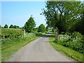
Entrance to Holliers House
Entrance to the house and stables at Holliers House, Just north of Middle Barton.
Image: © Mr Biz
Taken: 13 May 2008
0.05 miles
2
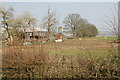
Down Hill Farm - farm buildings
On opposite side of road from farmhouse.
Image: © Gerry Lewis
Taken: 2 Apr 2007
0.09 miles
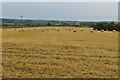
5
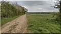
Bridleway to Duns Tew
From Worton Road the bridleway to Duns Tew
Image: © Shaun Ferguson
Taken: 30 Apr 2021
0.18 miles
6
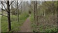
Path heading to Worton Road
From Middle Barton the path heading to Worton Road
Image: © Shaun Ferguson
Taken: 30 Apr 2021
0.21 miles