IMAGES TAKEN NEAR TO
Rayford Lane, CHIPPING NORTON, OX7 7DD
Introduction
This page details the photographs taken nearby to Rayford Lane, OX7 7DD by members of the Geograph project.
The Geograph project started in 2005 with the aim of publishing, organising and preserving representative images for every square kilometre of Great Britain, Ireland and the Isle of Man.

There are currently over 7.5m images from over14,400 individuals and you can help contribute to the project by visiting https://www.geograph.org.uk
Image Map (Loading...)


Getting Data...Please wait
Leaflet Map data © OpenStreetMap
Images are licensed for reuse under creativecommons.org/licenses/by-sa/2.0
Notes
- Clicking on the map will re-center to the selected point.
- The higher the marker number, the further away the image location is from the centre of the postcode.
Image Listing (7 Images Found)
Images are licensed for reuse under creativecommons.org/licenses/by-sa/2.0
Image
Details
Distance
1
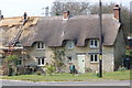
Old Toll House by the B4030, North Street, Bartongate
Toll House in the parish of Wescot Barton, Upper Turnpike Cottage, North Street (B4030), Bartongate, OX7 7DE.
Grade II listed.
List Entry Number: 1199567 https://historicengland.org.uk/listing/the-list/list-entry/1199567
Surveyed
Milestone Society National ID: OX.WEB01
Image: © Alan Rosevear
Taken: 16 Jan 2005
0.04 miles
3
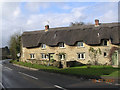
Thatched cottage being partly re-thatched
Image: © Gerry Lewis
Taken: 2 Apr 2007
0.06 miles
4
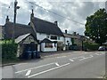
The Cinnamon Stick, Middle Barton
It's a Lebanese restaurant (and bar) now. The building looks like it may have been a pub in the past.
Image: © Bikeboy
Taken: 10 Aug 2021
0.18 miles
5
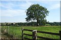
Countryside near Middle Barton
Gentle hills and shallow valleys, fields and small woods. A typical view for this area.
Image: © Des Blenkinsopp
Taken: 9 Sep 2023
0.21 miles
6
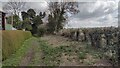
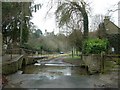
Rayford Lane
Rayford Lane track off Church Lane
Image: © Shaun Ferguson
Taken: 30 Apr 2021
0.21 miles
7
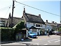
Middle Barton-The Cinnamon Stick
Lebanese Restaurant and Bar.
Image: © Ian Rob
Taken: 27 Jun 2019
0.23 miles