IMAGES TAKEN NEAR TO
Sarsden, CHIPPING NORTON, OX7 6PX
Introduction
This page details the photographs taken nearby to OX7 6PX by members of the Geograph project.
The Geograph project started in 2005 with the aim of publishing, organising and preserving representative images for every square kilometre of Great Britain, Ireland and the Isle of Man.

There are currently over 7.5m images from over14,400 individuals and you can help contribute to the project by visiting https://www.geograph.org.uk
Image Map (Loading...)


Getting Data...Please wait
Leaflet Map data © OpenStreetMap
Images are licensed for reuse under creativecommons.org/licenses/by-sa/2.0
Notes
- Clicking on the map will re-center to the selected point.
- The higher the marker number, the further away the image location is from the centre of the postcode.
Image Listing (6 Images Found)
Images are licensed for reuse under creativecommons.org/licenses/by-sa/2.0
Image
Details
Distance
1
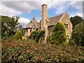
Sarsden Gorse
This unusually named house is alongside the minor road.
Image: © Michael Dibb
Taken: 10 Aug 2010
0.01 miles
2
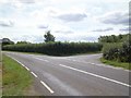
Country road junction
Behind the camera to Churchill, straight on to Lyneham, right to Bruern Abbey.
Image: © Michael Dibb
Taken: 10 Aug 2010
0.04 miles
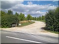
3
Sarsden Gorse junction
House, sign and road junction at Sarsden Gorse.
Image: © William Bartlett
Taken: 23 Oct 2006
0.04 miles
4
Farm drive
This driveway to Lyneham Heath Farm has been newly created. The original driveway, a few yards to the south east is now to Lyneham Heath House.
Image: © Michael Dibb
Taken: 10 Aug 2010
0.22 miles
5
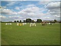
Horse jumps
Seen from the driveway to Lyneham Heath Farm.
Image: © Michael Dibb
Taken: 10 Aug 2010
0.24 miles
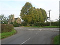
6
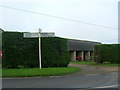
Sign outside Sarsden Lodge
Farm buildings of Sarsden Lodge can be seen behind. Photo taken from the T Junction at the end of Sarsden Lane
Image: © William Bartlett
Taken: 23 Oct 2006
0.25 miles