IMAGES TAKEN NEAR TO
OX7 6JE
Introduction
This page details the photographs taken nearby to OX7 6JE by members of the Geograph project.
The Geograph project started in 2005 with the aim of publishing, organising and preserving representative images for every square kilometre of Great Britain, Ireland and the Isle of Man.

There are currently over 7.5m images from over14,400 individuals and you can help contribute to the project by visiting https://www.geograph.org.uk
Image Map
Images are licensed for reuse under creativecommons.org/licenses/by-sa/2.0
Notes
- Clicking on the map will re-center to the selected point.
- The higher the marker number, the further away the image location is from the centre of the postcode.
Image Listing (20 Images Found)
Images are licensed for reuse under creativecommons.org/licenses/by-sa/2.0
Image
Details
Distance
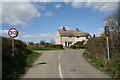
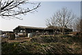
1
Barns and shelter
These large barns are seen from the road and are providing shelter for cattle.
Image: © Michael Dibb
Taken: 27 Nov 2011
0.01 miles
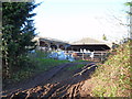
2
Barns with cattle
On the road from Idbury to Fifield
Image: © andrew auger
Taken: 21 Mar 2009
0.02 miles
3
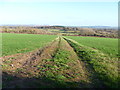
Track to the view
Seen from the road, the view is to Fifield Heath and beyond, over the valley of the River Evenlode, to Sarsden.
Image: © Michael Dibb
Taken: 27 Nov 2011
0.10 miles
4
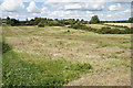
Roughly cut grass near Idbury
Idbury is visible in the trees ahead, and the route of the path is also clear.
Image: © Bill Boaden
Taken: 2 Aug 2020
0.16 miles
5
Towards Idbury
This short footpath starts here on the road from Fifield and runs into Idbury, cutting the corner. The field shows obvious signs of the Medieval 'ridge and furrow' system of ploughing.
Image: © Michael Dibb
Taken: 4 Jun 2010
0.16 miles
6
Footpath approaching Idbury
The path is not entirely clear in this rough pasture. Aim for the church, usually a good bet for footpath location.
Image: © Graham Horn
Taken: 15 Sep 2012
0.17 miles
7
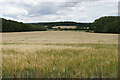
Barley field near Idbury
The field slopes down towards Idbury Brook which flows from Idbury into Littlestock Brook.
Image: © Bill Boaden
Taken: 2 Aug 2020
0.18 miles
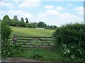
8
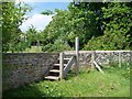
Steps to the ha ha
The footpath is raised to the level of the top of the ha ha by way of these steps.
Image: © Michael Dibb
Taken: 4 Jun 2010
0.18 miles
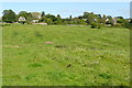
9
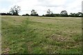
Path across a field of cut grass
The field is very uneven, possibly with lynchets, which has made the cutting of the grass also uneven.
Image: © Bill Boaden
Taken: 2 Aug 2020
0.18 miles