IMAGES TAKEN NEAR TO
Upper Milton, CHIPPING NORTON, OX7 6EY
Introduction
This page details the photographs taken nearby to Upper Milton, OX7 6EY by members of the Geograph project.
The Geograph project started in 2005 with the aim of publishing, organising and preserving representative images for every square kilometre of Great Britain, Ireland and the Isle of Man.

There are currently over 7.5m images from over14,400 individuals and you can help contribute to the project by visiting https://www.geograph.org.uk
Image Map
Images are licensed for reuse under creativecommons.org/licenses/by-sa/2.0
Notes
- Clicking on the map will re-center to the selected point.
- The higher the marker number, the further away the image location is from the centre of the postcode.
Image Listing (6 Images Found)
Images are licensed for reuse under creativecommons.org/licenses/by-sa/2.0
Image
Details
Distance
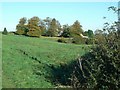
3
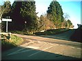
Crossroads by Springhill farm
Lane at crossroads by Springhill farm
Image: © Shaun Ferguson
Taken: 20 Feb 2011
0.09 miles
4
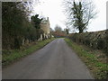
Lane passing Manor farm
Lane passing Manor farm Upper Milton
Image: © Shaun Ferguson
Taken: 20 Feb 2011
0.14 miles
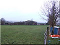
6
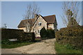
Springhill Farm
The vegetation in the dip before the farmhouse marks the location of a spring.
Image: © Jennifer Luther Thomas
Taken: 4 Nov 2006
0.16 miles