IMAGES TAKEN NEAR TO
Swinbrook Road, CHIPPING NORTON, OX7 6DU
Introduction
This page details the photographs taken nearby to Swinbrook Road, OX7 6DU by members of the Geograph project.
The Geograph project started in 2005 with the aim of publishing, organising and preserving representative images for every square kilometre of Great Britain, Ireland and the Isle of Man.

There are currently over 7.5m images from over14,400 individuals and you can help contribute to the project by visiting https://www.geograph.org.uk
Image Map (Loading...)


Getting Data...Please wait
Leaflet Map data © OpenStreetMap
Images are licensed for reuse under creativecommons.org/licenses/by-sa/2.0
Notes
- Clicking on the map will re-center to the selected point.
- The higher the marker number, the further away the image location is from the centre of the postcode.
Image Listing (8 Images Found)
Images are licensed for reuse under creativecommons.org/licenses/by-sa/2.0
Image
Details
Distance
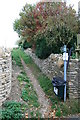
1
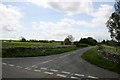
Fiddlers Hill, Shipton Under Wychwood
Leading off the Swinbrook Road.
Image: © andrew auger
Taken: 16 May 2009
0.13 miles
2
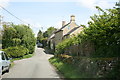
Road through Upper End, Shipton Under Wychwood
This leads to Fiddlers Hill
Image: © andrew auger
Taken: 16 May 2009
0.16 miles
3
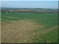
Oxfordshire fieldscape
A view of fields between Swinbrook lane and the B4437
Image: © Jennifer Luther Thomas
Taken: 4 Nov 2006
0.18 miles
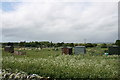
6
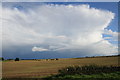
View across the fields
On the edge of Shipton Under Wychwood. With ominous looking clouds approaching.
Image: © andrew auger
Taken: 1 Sep 2009
0.23 miles
7
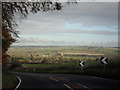
Top of the hill
On the A361 half a mile south of Shipton Under Wychwood, just before the descent to the village. Houses in the village can be seen in the photo in the valley below.
Image: © andrew auger
Taken: 6 Nov 2010
0.23 miles
8
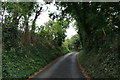
Narrow road through the trees
In Shipton Under Wychwood.
Image: © andrew auger
Taken: 23 Sep 2009
0.24 miles