IMAGES TAKEN NEAR TO
Maple Way, CHIPPING NORTON, OX7 6AU
Introduction
This page details the photographs taken nearby to Maple Way, OX7 6AU by members of the Geograph project.
The Geograph project started in 2005 with the aim of publishing, organising and preserving representative images for every square kilometre of Great Britain, Ireland and the Isle of Man.

There are currently over 7.5m images from over14,400 individuals and you can help contribute to the project by visiting https://www.geograph.org.uk
Image Map (Loading...)


Getting Data...Please wait
Leaflet Map data © OpenStreetMap
Images are licensed for reuse under creativecommons.org/licenses/by-sa/2.0
Notes
- Clicking on the map will re-center to the selected point.
- The higher the marker number, the further away the image location is from the centre of the postcode.
Image Listing (41 Images Found)
Images are licensed for reuse under creativecommons.org/licenses/by-sa/2.0
Image
Details
Distance
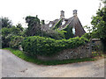
2
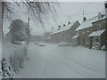
Ascott under Wychwood
Looking along the main street of the village. Many of the properties here are modern but still use Cotswold Stone to blend in. The village is still blessed with railway station on the main Oxford - Worcester line and so is well placed for commuting.
Image: © David Stowell
Taken: 3 Sep 2006
0.06 miles
3
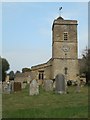
Ascott-under-Wychwood Holy Trinity Church
Parish Church. Late C12, altered C14 and restored 1857 by Street. Built of rubble with Cotswold stone roofs. Two-bay chancel, 3-bay nave with low north aisle, 3 stage west tower with plain parapet. Gabled south porch and south transept; vestry to north-east (1857-9). Two lower stages of tower and the side windows of chancel are circa 1200 lancets, latter in wide reveals, nave and north transept probably of the same period but with C14 windows of ogee pattern, a north door of that period in the aisle and a late C14 stepped 3-light lancet with cusped heads and nave (restored). Reticulated east window (possibly by Street). Paired C15 lancets to upper stages of tower and crenellation. Square-headed 2-light windows with stilted-arch lights to east and south walls of south transept. The south porch has Norman impost capitals and a chamfered archway with pyramidal steps; inner arch of early C13. Wooden priest's door with shouldered lintel. (britishlistedbuildings.co.uk)
Image: © Nick Barber
Taken: 4 Sep 2018
0.10 miles
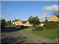
4
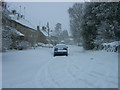
Shipston Road
Shipston Road in Ascott-under-Wychwood.
Image: © Philip Halling
Taken: 13 May 2024
0.12 miles
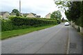
5
Church View, Ascott under Wychwood from Shipton Road
Image: © Maggie Lyon
Taken: 8 Feb 2007
0.12 miles
7
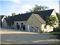
Tiddy Hall
The village hall in Ascott under Wychwood.
Image: © David Stowell
Taken: 3 Sep 2006
0.13 miles
8
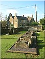
Ascott Barrow in its new home
The site of Ascott Barrow, a Neolithic burial chamber, is about 1 km south of here.
When it was excavated, the internal stonework was removed and kept in a museum, but in 2007 the stones were taken out of storage and laid out here in the old village pound.
Image: © Des Blenkinsopp
Taken: 16 May 2015
0.13 miles
9
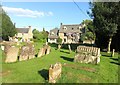
Leaning Tombstones
The one in front's straight.
Image: © Des Blenkinsopp
Taken: 16 May 2015
0.14 miles
10
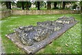
Ascott Barrow in the Pound
These stones are from the ancient Ascott Barrow have been relocated and place here within the village Pound. For more information see: Image
Image: © Philip Halling
Taken: 13 May 2024
0.14 miles