IMAGES TAKEN NEAR TO
Padley Close, CHIPPING NORTON, OX7 5WB
Introduction
This page details the photographs taken nearby to Padley Close, OX7 5WB by members of the Geograph project.
The Geograph project started in 2005 with the aim of publishing, organising and preserving representative images for every square kilometre of Great Britain, Ireland and the Isle of Man.

There are currently over 7.5m images from over14,400 individuals and you can help contribute to the project by visiting https://www.geograph.org.uk
Image Map (Loading...)


Getting Data...Please wait
Leaflet Map data © OpenStreetMap
Images are licensed for reuse under creativecommons.org/licenses/by-sa/2.0
Notes
- Clicking on the map will re-center to the selected point.
- The higher the marker number, the further away the image location is from the centre of the postcode.
Image Listing (11 Images Found)
Images are licensed for reuse under creativecommons.org/licenses/by-sa/2.0
Image
Details
Distance
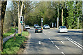
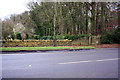
3
Applegarth Nursery on Banbury Road, Chipping Norton
The A44 here is V shaped, something I would avoid happening at all costs if I was a town planner. Both Banbury Road and London Road to the south, which goes from Oxford to the west of Wales, share this number.
Image: © David Howard
Taken: 3 Aug 2019
0.06 miles
4

It's cold out!
Display of statuary at Applegarth Nurseries, Chipping Norton.
Image: © Jonathan Billinger
Taken: 26 Nov 2011
0.06 miles
5
Applegarth Nursery on Banbury Road, Chipping Norton
Image: © David Howard
Taken: 3 Aug 2019
0.07 miles
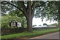
6
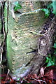
Benchmark on Banbury Road gatepost
Ordnance Survey cut mark benchmark described on the Bench Mark Database at http://www.bench-marks.org.uk/bm62816
Image: © Roger Templeman
Taken: 9 Dec 2014
0.12 miles
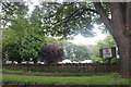
7
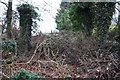
Blocked track from SW side of Banbury Road
There is an OS benchmark Image at the base of the left hand ivy-clad gatepost
Image: © Roger Templeman
Taken: 9 Dec 2014
0.13 miles
8

Chipping Norton Health Centre
A smart new facility on the east side of town.
Image: © Des Blenkinsopp
Taken: 13 Dec 2019
0.19 miles
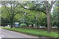
9
Hit or Miss Farm, Banbury Road (A44)
There is an OS benchmark Image on a corner stone in the wall on the right hand side of the entrance gateway to the farm
Image: © Roger Templeman
Taken: 9 Dec 2014
0.20 miles
10
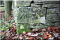
Benchmark on Banbury Road wall
Ordnance Survey cut mark benchmark described on the Bench Mark Database at http://www.bench-marks.org.uk/bm63001
Image: © Roger Templeman
Taken: 9 Dec 2014
0.21 miles