IMAGES TAKEN NEAR TO
Cotshill Gardens, CHIPPING NORTON, OX7 5UL
Introduction
This page details the photographs taken nearby to Cotshill Gardens, OX7 5UL by members of the Geograph project.
The Geograph project started in 2005 with the aim of publishing, organising and preserving representative images for every square kilometre of Great Britain, Ireland and the Isle of Man.

There are currently over 7.5m images from over14,400 individuals and you can help contribute to the project by visiting https://www.geograph.org.uk
Image Map (Loading...)


Getting Data...Please wait
Leaflet Map data © OpenStreetMap
Images are licensed for reuse under creativecommons.org/licenses/by-sa/2.0
Notes
- Clicking on the map will re-center to the selected point.
- The higher the marker number, the further away the image location is from the centre of the postcode.
Image Listing (78 Images Found)
Images are licensed for reuse under creativecommons.org/licenses/by-sa/2.0
Image
Details
Distance
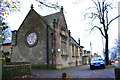
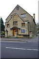
2
Junction of Cotshill Gardens and Banbury Road
The building with the cupola in the background is Norton Park, Listed Grade II for its special architectural and historic interest and is located in the Chipping Norton Conservation Area. The building dates back to 1836 and was designed by architect George Wilkinson as the Union Workhouse and later became Cotshill hospital before being converted to residential use in the mid 1990s.
Image: © Roger Templeman
Taken: 28 Nov 2014
0.05 miles
3
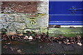
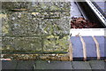
Benchmark on The Town Nursery
Ordnance Survey cut mark benchmark described on the Bench Mark Database at http://www.bench-marks.org.uk/bm62622
Image: © Roger Templeman
Taken: 28 Nov 2014
0.05 miles
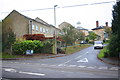
4
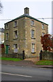
The Town Nursery, #24 London Road
There is an OS benchmark Image beside the blue door at the far end of the front of the building
Image: © Roger Templeman
Taken: 28 Nov 2014
0.05 miles
5
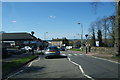
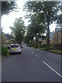
London Road, Chipping Norton
This can be the local bottleneck.
Image: © Bill Boaden
Taken: 8 Apr 2010
0.05 miles
6
'Fenton House', Banbury Road
There is an OS benchmark Image on the front of the house at the near corner
Image: © Roger Templeman
Taken: 28 Nov 2014
0.06 miles
7
Benchmark on Oddfellows Hall
Ordnance Survey cut mark benchmark described on the Bench Mark Database at http://www.bench-marks.org.uk/bm62619
Image: © Roger Templeman
Taken: 28 Nov 2014
0.06 miles
8
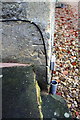
Benchmark on 'Fenton House'
Ordnance Survey cut mark benchmark described on the Bench Mark Database at http://www.bench-marks.org.uk/bm62620
Image: © Roger Templeman
Taken: 28 Nov 2014
0.07 miles
9
Oddfellows Hall, London Road
There is an OS benchmark Image on the front of the building at its right hand corner
Image: © Roger Templeman
Taken: 28 Nov 2014
0.07 miles
10
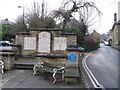
War Memorial, Chipping Norton
The memorial is sited between the A44 London Road, to the left, and Rock Hill, to the right.
Image: © Michael Dibb
Taken: 25 Jan 2010
0.10 miles