IMAGES TAKEN NEAR TO
Ellis Lane, CHIPPING NORTON, OX7 5UA
Introduction
This page details the photographs taken nearby to Ellis Lane, OX7 5UA by members of the Geograph project.
The Geograph project started in 2005 with the aim of publishing, organising and preserving representative images for every square kilometre of Great Britain, Ireland and the Isle of Man.

There are currently over 7.5m images from over14,400 individuals and you can help contribute to the project by visiting https://www.geograph.org.uk
Image Map
Images are licensed for reuse under creativecommons.org/licenses/by-sa/2.0
Notes
- Clicking on the map will re-center to the selected point.
- The higher the marker number, the further away the image location is from the centre of the postcode.
Image Listing (16 Images Found)
Images are licensed for reuse under creativecommons.org/licenses/by-sa/2.0
Image
Details
Distance
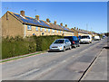
1
Walterbush Road, Chipping Norton
Looking WSW along Walterbush Road at the junction with Hailey Avenue.
Image: © David P Howard
Taken: 16 Mar 2014
0.09 miles
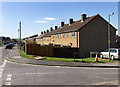
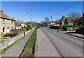
2
Walterbush Road, Chipping Norton
View NNE along Walterbush Road. Note how many properties have solar photovoltaic systems installed on their south east facing roofs.
Image: © David P Howard
Taken: 16 Mar 2014
0.11 miles
3
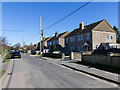
Walterbush Road, Chipping Norton
View NE along this residential road.
Image: © David P Howard
Taken: 16 Mar 2014
0.14 miles
4
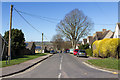
Hailey Road, Chipping Norton
View north west down Hailey Road from the junction with Walterbush Road.
Image: © David P Howard
Taken: 16 Mar 2014
0.17 miles
5
Walterbush Road, Chipping Norton
Looking NNE along this residential road.
Image: © David P Howard
Taken: 16 Mar 2014
0.17 miles
6
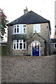
#79 Burford Road, 'Lindisfarne'
There is an OS benchmark Image on the side of the house at the front corner
Image: © Roger Templeman
Taken: 5 Dec 2014
0.21 miles
7
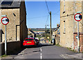
The Leys, Chipping Norton
The junction of The Leys with Churchill Road.
Image: © David P Howard
Taken: 16 Mar 2014
0.21 miles
8
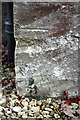
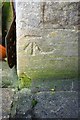
Benchmark on #79 Burford Road
Ordnance Survey cut mark benchmark described on the Bench Mark Database at http://www.bench-marks.org.uk/bm62764
Image: © Roger Templeman
Taken: 5 Dec 2014
0.21 miles
9
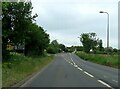
Burford Road entering Chipping Norton
Image: © Steve Daniels
Taken: 31 May 2023
0.23 miles
10
Benchmark on #24 West End
Ordnance Survey cut mark benchmark described on the Bench Mark Database at http://www.bench-marks.org.uk/bm62612
Image: © Roger Templeman
Taken: 24 Nov 2014
0.24 miles