IMAGES TAKEN NEAR TO
Great Rollright, CHIPPING NORTON, OX7 5SQ
Introduction
This page details the photographs taken nearby to OX7 5SQ by members of the Geograph project.
The Geograph project started in 2005 with the aim of publishing, organising and preserving representative images for every square kilometre of Great Britain, Ireland and the Isle of Man.

There are currently over 7.5m images from over14,400 individuals and you can help contribute to the project by visiting https://www.geograph.org.uk
Image Map
Images are licensed for reuse under creativecommons.org/licenses/by-sa/2.0
Notes
- Clicking on the map will re-center to the selected point.
- The higher the marker number, the further away the image location is from the centre of the postcode.
Image Listing (6 Images Found)
Images are licensed for reuse under creativecommons.org/licenses/by-sa/2.0
Image
Details
Distance
1
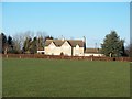
Hill Court, Great Rollright
Seen from the footpath from Ascott to Great Rollright.
Image: © Michael Dibb
Taken: 3 Jan 2010
0.01 miles
2
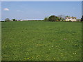
Seven Shires Way
Seven Shires Way footpath passing Hill Court
Image: © Shaun Ferguson
Taken: 23 Apr 2011
0.04 miles
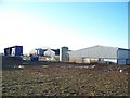
4
![Wall of straw [2]](https://s1.geograph.org.uk/geophotos/01/66/00/1660041_98a19b4c_120x120.jpg)
Wall of straw [2]
At Hutton Grange Farm, the right of way follows a straight line, in line with the two gates on the driveway, through the wall of straw.
Image: © Michael Dibb
Taken: 3 Jan 2010
0.10 miles
5
![Wall of straw [1]](https://s2.geograph.org.uk/geophotos/01/66/00/1660022_e104a46a_120x120.jpg)
Wall of straw [1]
At Hutton Grange Farm this wall of straw bales has been constructed. The right of way passes through the middle of the wall.
Image: © Michael Dibb
Taken: 3 Jan 2010
0.11 miles
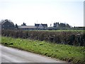
6
Hutton Grange Farm
Seen from the footpath, the ground in front of the buildings is a frozen churned-up muddy wasteland. The farm seems to be in two parts, with the barns etc some distance from the farmhouse which is alongside the minor road.
Image: © Michael Dibb
Taken: 12 Jan 2010
0.14 miles