IMAGES TAKEN NEAR TO
The Green, CHIPPING NORTON, OX7 5RN
Introduction
This page details the photographs taken nearby to The Green, OX7 5RN by members of the Geograph project.
The Geograph project started in 2005 with the aim of publishing, organising and preserving representative images for every square kilometre of Great Britain, Ireland and the Isle of Man.

There are currently over 7.5m images from over14,400 individuals and you can help contribute to the project by visiting https://www.geograph.org.uk
Image Map
Images are licensed for reuse under creativecommons.org/licenses/by-sa/2.0
Notes
- Clicking on the map will re-center to the selected point.
- The higher the marker number, the further away the image location is from the centre of the postcode.
Image Listing (41 Images Found)
Images are licensed for reuse under creativecommons.org/licenses/by-sa/2.0
Image
Details
Distance
1
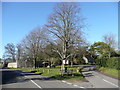
Village green, Great Rollright
The triangle formed at the T junction of lanes to the west of the village centre.
Image: © Jonathan Billinger
Taken: 30 Jan 2008
0.02 miles
2
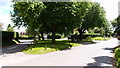
Village Green
Plenty of shade and seating on the village green on a sunny day in the summer of 2016.
Image: © Michael Trolove
Taken: 3 Jul 2016
0.03 miles
3
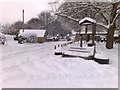
The tiny village green, under snow
Image: © Dave Favis-Mortlock
Taken: 19 Dec 2010
0.03 miles
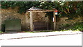
4
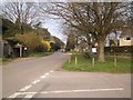
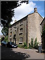
The Green
The Green in Great Rollright is adjacent to High Street.
Image: © Michael Dibb
Taken: 27 Mar 2011
0.04 miles
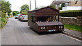
5
Bus Shelter (Luxury version)
A well appointed bus shelter in Great Rollright.
Image: © Michael Trolove
Taken: 3 Jul 2016
0.04 miles
6
Motorised garden shed
Fully road legal and capable of over 80mph. Certainly made me smile when I first saw it. The owner was kind enough to tell me about its construction. Full details on many social media sites
Image: © Michael Trolove
Taken: 3 Jul 2016
0.05 miles
7
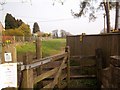
To Church End
A short footpath runs across an open field in the middle of the village linking The Green with Church End.
Image: © Michael Dibb
Taken: 27 Mar 2011
0.05 miles
8
Field by D'Arcy Dalton Way
Footpath 329 13/10 cuts across Hemplands Image], and is seen from where it meets the D'Arcy Dalton Way.
Image: © Derek Harper
Taken: 10 Feb 2022
0.06 miles
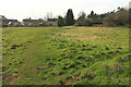
9

Hemplands, Great Rollright
Looking right from Image] across the field associated with a history of hemp cultivation.
Image: © Derek Harper
Taken: 10 Feb 2022
0.06 miles
10
Former Pub/Hotel, Great Rollright
Now boarded up this three storey building appears to have been a pub or hotel. There is a plaque on the front with the name Hunt Edmunds Image which I think is a brewery in Banbury.
Image: © Philip Halling
Taken: 1 Aug 2006
0.08 miles