IMAGES TAKEN NEAR TO
Southcombe, CHIPPING NORTON, OX7 5QH
Introduction
This page details the photographs taken nearby to OX7 5QH by members of the Geograph project.
The Geograph project started in 2005 with the aim of publishing, organising and preserving representative images for every square kilometre of Great Britain, Ireland and the Isle of Man.

There are currently over 7.5m images from over14,400 individuals and you can help contribute to the project by visiting https://www.geograph.org.uk
Image Map
Images are licensed for reuse under creativecommons.org/licenses/by-sa/2.0
Notes
- Clicking on the map will re-center to the selected point.
- The higher the marker number, the further away the image location is from the centre of the postcode.
Image Listing (37 Images Found)
Images are licensed for reuse under creativecommons.org/licenses/by-sa/2.0
Image
Details
Distance
1
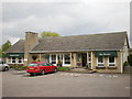
The Quiet Woman Antique Centre, Southcoombe
Image: © Alexander P Kapp
Taken: 15 May 2009
0.00 miles
2
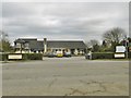
Southcombe, antiques centre
Quiet Woman Antiques Centre, on A44. The centre is so called because it was once the site of a pub of the same name. http://www.quietwomanantiques.co.uk/
Image: © Mike Faherty
Taken: 19 Feb 2017
0.00 miles
3
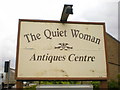
The Quiet Woman Antique Centre, Southcoombe, Sign
Image: © Alexander P Kapp
Taken: 15 May 2009
0.00 miles
4
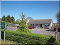
A contradiction in terms?
The antique centre alongside the A44 road is named The Quiet Woman.
Image: © Michael Dibb
Taken: 2 May 2011
0.00 miles
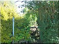
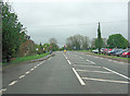
5
Towards the A44
As the track nears the A44 road, it has been diverted to the left to avoid exiting onto the A44 at the traffic lights. The line of the public footpath however follows the original line of the track but is seemingly little used.
Image: © Michael Dibb
Taken: 2 May 2011
0.02 miles
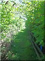
6
Start of footpath
As the track nears the A44 road, it has been diverted to the left to avoid exiting onto the A44 at the traffic lights. The line of the public footpath however follows the original line of the track but is seemingly little used.
Image: © Michael Dibb
Taken: 2 May 2011
0.02 miles
7
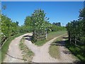
Two tracks
The track to the valley bottom, also a public footpath, is to the left and runs in a straight line. The newly created track to the right runs sinuously through the recently planted trees to Keepers House.
Image: © Michael Dibb
Taken: 2 May 2011
0.02 miles
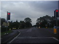
8
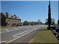
Junction of the A44s
The traffic lights control the junction of three roads all designated as the A44. The road on the left leads to a junction with the A361 and A3400 (formerly the A34) roads. The road straight ahead leads to Oxford via Woodstock. The road to the right at the lights leads to Worcester via Chipping Norton and Evesham.
Image: © Michael Dibb
Taken: 2 May 2011
0.03 miles
9
A44 junction with London Road
There's a bit of streetmap schizophrenia going on here, with all three roads at this three-way junction being designated as the A44.
Image: © Stuart Logan
Taken: 12 May 2013
0.03 miles
10
The A44 at the junction of London Road, Southcombe
According to the map the A44 is a triangular shape here, with both the London Road from Chipping Norton on the right and this road all sharing the same number. It certainly confused me as I should have been coming from the road on the right myself but the signposting sends everyone around the houses. The Quiet Woman antiques centre is on the left.
Image: © David Howard
Taken: 21 Aug 2012
0.03 miles