IMAGES TAKEN NEAR TO
Salford, CHIPPING NORTON, OX7 5QD
Introduction
This page details the photographs taken nearby to OX7 5QD by members of the Geograph project.
The Geograph project started in 2005 with the aim of publishing, organising and preserving representative images for every square kilometre of Great Britain, Ireland and the Isle of Man.

There are currently over 7.5m images from over14,400 individuals and you can help contribute to the project by visiting https://www.geograph.org.uk
Image Map
Images are licensed for reuse under creativecommons.org/licenses/by-sa/2.0
Notes
- Clicking on the map will re-center to the selected point.
- The higher the marker number, the further away the image location is from the centre of the postcode.
Image Listing (11 Images Found)
Images are licensed for reuse under creativecommons.org/licenses/by-sa/2.0
Image
Details
Distance
1
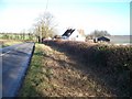
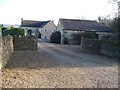
Windmill Cottages
The minor road runs from the A44 towards Great Rollright. The buildings of Windmill Farm can be seen at the back of the cottages.
Image: © Michael Dibb
Taken: 10 Dec 2009
0.01 miles
2
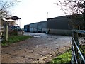
Windmill Farmyard
Seen from the minor road to Great Rollright.
Image: © Michael Dibb
Taken: 10 Dec 2009
0.03 miles
3
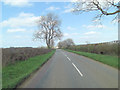
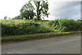
Un-named road northwest of Twin Brook Farm
Image: © Stuart Logan
Taken: 13 Apr 2014
0.04 miles
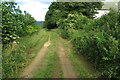
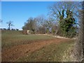
6
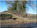
Path leaves the road
The footpath connecting the two minor roads follows the field edge.
Image: © Michael Dibb
Taken: 19 Feb 2010
0.07 miles

8
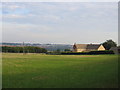
View towards Chipping Norton
Looking diagonally across the square with Chipping Norton visible in the distance. The nearby buildings are those of Twin Brook Farm.
Image: © David Stowell
Taken: 9 Sep 2006
0.13 miles
10
Bends in the path
The path takes a gentle S bend and ascends a small rise as it passes over the crest of the ridge.
Image: © Michael Dibb
Taken: 19 Feb 2010
0.18 miles