IMAGES TAKEN NEAR TO
The Green, CHIPPING NORTON, OX7 5PT
Introduction
This page details the photographs taken nearby to The Green, OX7 5PT by members of the Geograph project.
The Geograph project started in 2005 with the aim of publishing, organising and preserving representative images for every square kilometre of Great Britain, Ireland and the Isle of Man.

There are currently over 7.5m images from over14,400 individuals and you can help contribute to the project by visiting https://www.geograph.org.uk
Image Map
Images are licensed for reuse under creativecommons.org/licenses/by-sa/2.0
Notes
- Clicking on the map will re-center to the selected point.
- The higher the marker number, the further away the image location is from the centre of the postcode.
Image Listing (34 Images Found)
Images are licensed for reuse under creativecommons.org/licenses/by-sa/2.0
Image
Details
Distance
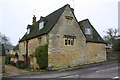
1
Over Norton War Memorial
Set into the end of the cottages in Image
Image: © David Stowell
Taken: 9 Sep 2006
0.04 miles
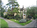
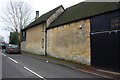
2
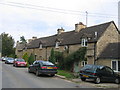
Over Norton
A row of cottages in the main street with Image set into the wall at the end nearest the photographer.
Image: © David Stowell
Taken: 9 Sep 2006
0.04 miles
3
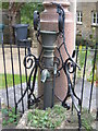
The Pump
A close up of the remarkable Image - even the pump body itself is ornate, although the tap is presumably a more modern addition!
Image: © David Stowell
Taken: 9 Sep 2006
0.04 miles
4
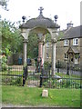
Village pump, Over Norton
The very elaborate structure built to house the village pump. The plaque reads "This fountain was erected in the memory of Colonel Henry Dawkins of Over Norton and of Emma M Dawkins his wife by their four surviving children". Even Image itself is ornately decorated.
Image: © David Stowell
Taken: 9 Sep 2006
0.04 miles
5
Village pump, Over Norton
The very ornate village pump by the village green in the heart of this otherwise fairly simple village.
Image: © David Stowell
Taken: 9 Sep 2006
0.04 miles
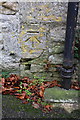
6
#34 Main Street
There is an OS benchmark Image on the road face of the house at the near angle
Image: © Roger Templeman
Taken: 1 Dec 2014
0.05 miles
7
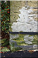
Benchmark on #34 Main Street
Ordnance Survey cut mark benchmark described on the Bench Mark Database at http://www.bench-marks.org.uk/bm62625
Image: © Roger Templeman
Taken: 1 Dec 2014
0.05 miles
8
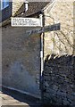
Pre Worboys finger post sign
Old style sign at the junction of Main Street and Choicehill Lane.
Image: © David P Howard
Taken: 16 Mar 2014
0.05 miles
9
#37 Main Street and neighbouring barn
There is an OS benchmark Image at the junction of the house and the barn, left of the black downpipe
Image: © Roger Templeman
Taken: 1 Dec 2014
0.08 miles
10
Benchmark on #37 Main Street
Ordnance Survey cut mark benchmark described on the Bench Mark Database at http://www.bench-marks.org.uk/bm62504
Image: © Roger Templeman
Taken: 1 Dec 2014
0.08 miles