IMAGES TAKEN NEAR TO
Folland Close, CHIPPING NORTON, OX7 5NB
Introduction
This page details the photographs taken nearby to Folland Close, OX7 5NB by members of the Geograph project.
The Geograph project started in 2005 with the aim of publishing, organising and preserving representative images for every square kilometre of Great Britain, Ireland and the Isle of Man.

There are currently over 7.5m images from over14,400 individuals and you can help contribute to the project by visiting https://www.geograph.org.uk
Image Map (Loading...)


Getting Data...Please wait
Leaflet Map data © OpenStreetMap
Images are licensed for reuse under creativecommons.org/licenses/by-sa/2.0
Notes
- Clicking on the map will re-center to the selected point.
- The higher the marker number, the further away the image location is from the centre of the postcode.
Image Listing (258 Images Found)
Images are licensed for reuse under creativecommons.org/licenses/by-sa/2.0
Image
Details
Distance
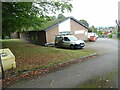
1
Chipping Norton Telephone Exchange (2)
This photo shows the west side of the TE with sycamore trees in the foreground. This TE has the numbering range (01608) 64xxxx, the (01608) referring to the thirteen TEs in the Chipping Norton group, and its postcode is OX7 5AW.
Image: © David Hillas
Taken: 7 Oct 2021
0.02 miles
2
Chipping Norton Telephone Exchange (1)
Situated on the A361 Banbury Road, this building dates from the 1960s replacing the Manual TE in the town and has the code SMCN. It provides telephone and broadband services to approximately 3,185 residential and 291 non-residential premises in Chipping Norton and the nearby villages of Over Norton and Salford. A yellow grit salt bin can be seen to the left of the photo whilst an Openreach van is parked in front of the TE.
Image: © David Hillas
Taken: 7 Oct 2021
0.03 miles
3
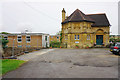
Former Chipping Norton Memorial Hospital
Likely to become a Premier Inn soon.
Image: © Bill Boaden
Taken: 19 Aug 2015
0.03 miles

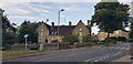
5

Banbury Road - viewed from London Road
Image: © Betty Longbottom
Taken: 12 Aug 2013
0.04 miles
6
Former Police Station, London Road
The former police station is boarded up and neglected, awaiting new owners. See Image
Image: © Paul Collins
Taken: 19 Aug 2021
0.04 miles
7
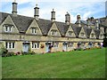
Chipping Norton Almshouses
Almshouses near St Mary's Church, built in 1640
Image: © John Pridham
Taken: 19 Aug 2006
0.04 miles
8

Chipping Norton: The Chequers PH sign
Image: © Michael Garlick
Taken: 14 Jun 2022
0.04 miles
9

Over Norton Road - viewed from London Road
Image: © Betty Longbottom
Taken: 12 Aug 2013
0.04 miles
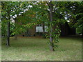
10
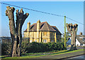
Horse Chestnut Trees and the masonic lodge in Over Norton Road
Situated on the B4026 on the north side of the town.
Image: © Clive Perrin
Taken: 28 Jan 2006
0.04 miles