IMAGES TAKEN NEAR TO
Cooks Lane, CHIPPING NORTON, OX7 5FF
Introduction
This page details the photographs taken nearby to Cooks Lane, OX7 5FF by members of the Geograph project.
The Geograph project started in 2005 with the aim of publishing, organising and preserving representative images for every square kilometre of Great Britain, Ireland and the Isle of Man.

There are currently over 7.5m images from over14,400 individuals and you can help contribute to the project by visiting https://www.geograph.org.uk
Image Map (Loading...)


Getting Data...Please wait
Leaflet Map data © OpenStreetMap
Images are licensed for reuse under creativecommons.org/licenses/by-sa/2.0
Notes
- Clicking on the map will re-center to the selected point.
- The higher the marker number, the further away the image location is from the centre of the postcode.
Image Listing (67 Images Found)
Images are licensed for reuse under creativecommons.org/licenses/by-sa/2.0
Image
Details
Distance
1
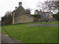
Village playground
Village playground by Cooks Lane in Salford
Image: © Shaun Ferguson
Taken: 27 Mar 2011
0.02 miles
2
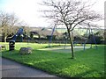
Play area, Salford
The children's play area is set between Cooks Lane and Roses Lane.
Image: © Michael Dibb
Taken: 10 Dec 2009
0.03 miles
3
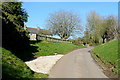
Roses Lane
Looking north towards the crossroads at the north end of Salford village. The playground, with a useful bench for use as a lunch spot when walking, is to the left. This lane is used by Shakespeare's Way.
Image: © Graham Horn
Taken: 17 Feb 2013
0.04 miles
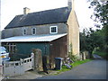
4
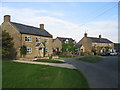
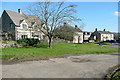
Salford
Some of the houses at the north eastern extremity of the village near Larches Farm, just inside the western boundary of this square.
Image: © David Stowell
Taken: 9 Sep 2006
0.05 miles
5
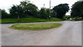
Road junction and grass triangle
Road feature in Salford.
Image: © Michael Trolove
Taken: 3 Jul 2016
0.06 miles
6
Houses on Roses Lane
These are passed on Shakespeare's Way. The petrol pump is old, and probably not in its original location, but would be a complete oddity to our man.
Image: © Graham Horn
Taken: 17 Feb 2013
0.08 miles
7
Houses in Salford
These are some of the houses at the northern end of the village. There is a hint of Cotswold stone here. Shakespeare's Way passes through the village, but left to right not in the direction of the view.
Image: © Graham Horn
Taken: 17 Feb 2013
0.08 miles
8
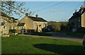
Houses at the top of the village
The village doesn't have any twee cottages, but nevertheless all the buildings seem to have strict planning rules to abide by.
Image: © Bill Boaden
Taken: 8 Apr 2010
0.09 miles

10
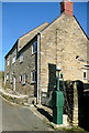
Old pump, Salford
An old petrol pump still in situ in the lane around the village.
Image: © David Stowell
Taken: 9 Sep 2006
0.12 miles