IMAGES TAKEN NEAR TO
Russell Way, CHIPPING NORTON, OX7 5FA
Introduction
This page details the photographs taken nearby to Russell Way, OX7 5FA by members of the Geograph project.
The Geograph project started in 2005 with the aim of publishing, organising and preserving representative images for every square kilometre of Great Britain, Ireland and the Isle of Man.

There are currently over 7.5m images from over14,400 individuals and you can help contribute to the project by visiting https://www.geograph.org.uk
Image Map (Loading...)


Getting Data...Please wait
Leaflet Map data © OpenStreetMap
Images are licensed for reuse under creativecommons.org/licenses/by-sa/2.0
Notes
- Clicking on the map will re-center to the selected point.
- The higher the marker number, the further away the image location is from the centre of the postcode.
Image Listing (24 Images Found)
Images are licensed for reuse under creativecommons.org/licenses/by-sa/2.0
Image
Details
Distance
1

Chipping Norton Health Centre
A smart new facility on the east side of town.
Image: © Des Blenkinsopp
Taken: 13 Dec 2019
0.07 miles
2

London Road Retail Park, Chipping Norton
Originally called Trinity Retail Park in the plans, it was actually named the London Road Retail Park when it was recently completed on an existing car park. https://completelyretail.co.uk/scheme/Trinity-Retail-Park-Chipping-Norton
Image: © David Howard
Taken: 10 Sep 2019
0.09 miles
3
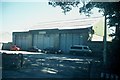
Former Bus Garage, Chipping Norton (1)
This photo shows the former bus garage in (A44) London Road OX7 5AX which was owned by City of Oxford Motor Services Ltd and for some decades, provided vehicles for the bus route between Chipping Norton and Oxford via Woodstock. Since this photo was taken in July 2006, it has been demolished although Stagecoach in Oxfordshire now has an outstation nearby for eight Scania N230 double deckers 15830-15837 to cover Superior route S3 between the same places.
Image: © David Hillas
Taken: 11 Jul 2006
0.09 miles
4
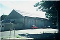
Former Bus Garage, Chipping Norton (2)
Taken on a bright sunny day in July 2006, this photo shows the former bus garage on the A44 London Road which was formerly owned by City of Oxford Motor Services Ltd. Bus services by that operator began in 1919 between Chipping Norton and Oxford via Woodstock using vehicles based at this garage. Since this photo was taken, the garage has been demolished although Stagecoach in Oxfordshire has an Outstation nearby for eight double-deck buses covering Superior route S3 between Chipping Norton/Charlbury and Oxford via Woodstock.
Image: © David Hillas
Taken: 11 Jul 2006
0.10 miles
5

London Road Retail Park, Chipping Norton
Image: © David Howard
Taken: 21 Jan 2020
0.10 miles
6
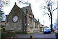
Junction of Cotshill Gardens and Banbury Road
The building with the cupola in the background is Norton Park, Listed Grade II for its special architectural and historic interest and is located in the Chipping Norton Conservation Area. The building dates back to 1836 and was designed by architect George Wilkinson as the Union Workhouse and later became Cotshill hospital before being converted to residential use in the mid 1990s.
Image: © Roger Templeman
Taken: 28 Nov 2014
0.10 miles
7

Benchmark on The Town Nursery
Ordnance Survey cut mark benchmark described on the Bench Mark Database at http://www.bench-marks.org.uk/bm62622
Image: © Roger Templeman
Taken: 28 Nov 2014
0.13 miles
8
The Town Nursery, #24 London Road
There is an OS benchmark Image beside the blue door at the far end of the front of the building
Image: © Roger Templeman
Taken: 28 Nov 2014
0.13 miles
9

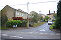
New housing development on London Road
The old factories opposite have been demolished and replaced with a housing estate, while these appear to have been built on a green field site as previously the road was lined with trees and had no buildings behind them.
Image: © David Howard
Taken: 21 Aug 2012
0.13 miles
10
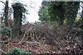
Blocked track from SW side of Banbury Road
There is an OS benchmark Image at the base of the left hand ivy-clad gatepost
Image: © Roger Templeman
Taken: 9 Dec 2014
0.14 miles