IMAGES TAKEN NEAR TO
West Street, CHIPPING NORTON, OX7 5EU
Introduction
This page details the photographs taken nearby to West Street, OX7 5EU by members of the Geograph project.
The Geograph project started in 2005 with the aim of publishing, organising and preserving representative images for every square kilometre of Great Britain, Ireland and the Isle of Man.

There are currently over 7.5m images from over14,400 individuals and you can help contribute to the project by visiting https://www.geograph.org.uk
Image Map (Loading...)


Getting Data...Please wait
Leaflet Map data © OpenStreetMap
Images are licensed for reuse under creativecommons.org/licenses/by-sa/2.0
Notes
- Clicking on the map will re-center to the selected point.
- The higher the marker number, the further away the image location is from the centre of the postcode.
Image Listing (232 Images Found)
Images are licensed for reuse under creativecommons.org/licenses/by-sa/2.0
Image
Details
Distance
1
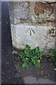
Benchmark on #58 West Street
Ordnance Survey pivot benchmark described on the Bench Mark Database at http://www.bench-marks.org.uk/bm62345
Image: © Roger Templeman
Taken: 24 Nov 2014
0.01 miles
3
Junction of West Street and Bell Yard
There is an OS benchmark Image on the front of the right hand house on the base quoin at its left hand corner
Image: © Roger Templeman
Taken: 24 Nov 2014
0.02 miles
4
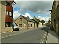
Mill View, West Street, Chipping Norton
The mill in question presumably being Bliss Mill in the valley bottom.
Image: © Stephen Craven
Taken: 20 Sep 2021
0.02 miles
5
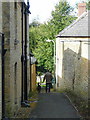
Alleyway leading off West Street
Looking west towards a man walking his dog.
Image: © Jonathan Billinger
Taken: 1 Oct 2008
0.03 miles
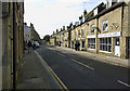
6
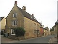
Chipping Norton: B4450 West Street
West Street is the B4450 and leads south-westwards out of the town. The house on the left is a Grade II Listed building dating from the 17th Century.
Image: © Nigel Cox
Taken: 30 May 2015
0.03 miles
8
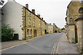
West Street, Chipping Norton
The B4450 which gets to Stow-on-the-Wold by a slightly rambling route.
Image: © Bill Boaden
Taken: 19 Aug 2015
0.04 miles
9
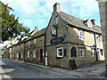
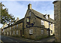
The Bell, West Street, Chipping Norton
Pub with accommodation = inn.
Image: © Jonathan Billinger
Taken: 1 Oct 2008
0.04 miles
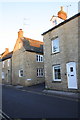
10
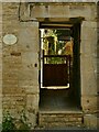
College Place, West Street, Chipping Norton - detail
A former 17th century farmhouse, listed grade II (list entry 1284046). See Image for context. The plaque to the left records that the building was erected by Brasenose College, Oxford (patron of the living) and originally occupied by a vicar. I'm informed by the Diocese of Oxford that since a pastoral scheme dated May 2001 uniting the benefice of Chipping Norton with others, the college no longer has a share of the patronage.
Image: © Stephen Craven
Taken: 20 Sep 2021
0.04 miles