IMAGES TAKEN NEAR TO
Hailey Road, CHIPPING NORTON, OX7 5EA
Introduction
This page details the photographs taken nearby to Hailey Road, OX7 5EA by members of the Geograph project.
The Geograph project started in 2005 with the aim of publishing, organising and preserving representative images for every square kilometre of Great Britain, Ireland and the Isle of Man.

There are currently over 7.5m images from over14,400 individuals and you can help contribute to the project by visiting https://www.geograph.org.uk
Image Map (Loading...)


Getting Data...Please wait
Leaflet Map data © OpenStreetMap
Images are licensed for reuse under creativecommons.org/licenses/by-sa/2.0
Notes
- Clicking on the map will re-center to the selected point.
- The higher the marker number, the further away the image location is from the centre of the postcode.
Image Listing (18 Images Found)
Images are licensed for reuse under creativecommons.org/licenses/by-sa/2.0
Image
Details
Distance
1
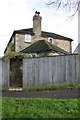
#59 Churchill Road
There is an OS benchmark Image on the left hand side of the house behind a climbing plant visible through the gate
Image: © Roger Templeman
Taken: 5 Dec 2014
0.01 miles
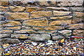
2
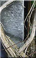
Benchmark on #59 Churchill Road
Ordnance Survey cut mark benchmark described on the Bench Mark Database at http://www.bench-marks.org.uk/bm62765
Image: © Roger Templeman
Taken: 5 Dec 2014
0.02 miles
3
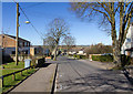
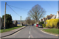
Hailey Road, Chipping Norton
Looking WNW down Hailey Road.
Note the white paint markings on the road in the foreground delineating the pot holes to be filled in.
Image: © David P Howard
Taken: 16 Mar 2014
0.03 miles
4
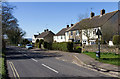
Churchill Road, Chipping Norton
The B4450 Churchill Road heads WSW out of Chipping Norton heading towards Churchill.
Image: © David P Howard
Taken: 16 Mar 2014
0.05 miles
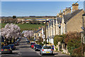
5
Hailey Road, Chipping Norton
View north west down Hailey Road from the junction with Walterbush Road.
Image: © David P Howard
Taken: 16 Mar 2014
0.14 miles
6
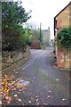
Drive beside #2 Grace Cottage, The Leys
There is an OS benchmark Image on the stone wall on the left hand side of the drive about 1m from the far end of the wall
Image: © Roger Templeman
Taken: 28 Nov 2014
0.16 miles
7
Walterbush Road, Chipping Norton
View NNE along Walterbush Road. Note how many properties have solar photovoltaic systems installed on their south east facing roofs.
Image: © David P Howard
Taken: 16 Mar 2014
0.17 miles
8
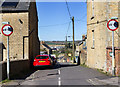
The Leys, Chipping Norton
The junction of The Leys with Churchill Road.
Image: © David P Howard
Taken: 16 Mar 2014
0.17 miles
9
Benchmark on drive wall beside Grace Cottage
Ordnance Survey cut mark benchmark described on the Bench Mark Database at http://www.bench-marks.org.uk/bm62615
Image: © Roger Templeman
Taken: 28 Nov 2014
0.17 miles
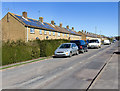
10
The Leys, Chipping Norton
Looking north west down The Leys.
Image: © David P Howard
Taken: 16 Mar 2014
0.19 miles