IMAGES TAKEN NEAR TO
The Drive, CHIPPING NORTON, OX7 4NQ
Introduction
This page details the photographs taken nearby to The Drive, OX7 4NQ by members of the Geograph project.
The Geograph project started in 2005 with the aim of publishing, organising and preserving representative images for every square kilometre of Great Britain, Ireland and the Isle of Man.

There are currently over 7.5m images from over14,400 individuals and you can help contribute to the project by visiting https://www.geograph.org.uk
Image Map (Loading...)


Getting Data...Please wait
Leaflet Map data © OpenStreetMap
Images are licensed for reuse under creativecommons.org/licenses/by-sa/2.0
Notes
- Clicking on the map will re-center to the selected point.
- The higher the marker number, the further away the image location is from the centre of the postcode.
Image Listing (53 Images Found)
Images are licensed for reuse under creativecommons.org/licenses/by-sa/2.0
Image
Details
Distance
1
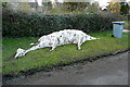
Dinosaur or Dolphin?
My walking companion thought it was the remains of a snow dinosaur (head this end). I saw more of a dolphin in it, or perhaps a porpoise (head that end). Whatever, this snow sculpture still retains some shape days after the rest of the snow had melted.
Image: © Graham Horn
Taken: 17 Feb 2013
0.02 miles
3
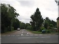
Crossing Spring Hill
Shakespeare's Way uses a footpath across this field at Spring Hill. The view is south, towards houses on Bicester Road, Enstone.
Image: © Graham Horn
Taken: 17 Feb 2013
0.07 miles
4
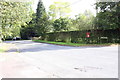
Junction of The Drive and Bicester Road
There is a post box on a post at the junction
Image: © Roger Templeman
Taken: 3 Oct 2014
0.07 miles
5
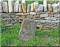
Old Milestone by the B4030, Bicester Road, Enstone
Carved stone post by the B4030, in parish of ENSTONE (WEST OXFORDSHIRE District), Bicester Road; opposite North end of Old People's bungalow (No. 13), and opposite slip road down to the A44, back to a collapsed (and rebuilt) dry stone wall, on verge between elders, on North side of road by allotments. Enstone limestone pillar, erected by the Enstone, Heyford, Bicester, Weston & Kirtlington turnpike trust in the 19th century.
Inscription once read:-
(BICESTER)
(14)
Oxfordshire HER.
HER Number: 10092 https://www.heritagegateway.org.uk/Gateway/Results_Single.aspx?uid=MOX898&resourceID=1033
Milestone Society National ID: OX_ENBC00.
Image: © A Rosevear
Taken: 31 Aug 2003
0.07 miles
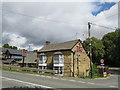
6
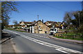
The Harrow Inn, Enstone
Situated on the A44. When the nearby Heythrop Park was a NatWest management training college, the Harrow Inn was the evening refuge.
Image: © Bill Boaden
Taken: 8 Apr 2010
0.08 miles
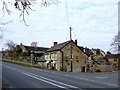
8

The Harrow on Oxford Road
The Harrow is a former Morrells pub.
Image: © Steve Daniels
Taken: 21 Jun 2014
0.09 miles
9
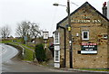
Harrow, good buy? Or goodbye Harrow?
A potentially good location at one end of Enstone village for local use, but the adjacent A44 is not a good place to stop, or even turn in in a hurry. Let's hope a buyer is found.
Image: © Graham Horn
Taken: 24 Feb 2013
0.10 miles
10
The Artyard Caf? Bar, Enstone
The Artyard café bar in Enstone, in Oxfordshire. The building used to be The Harrow pub, here are some older images taken by other contributors:
Image
Image
Image
Image: © Malc McDonald
Taken: 1 Aug 2020
0.10 miles