IMAGES TAKEN NEAR TO
Gagingwell, CHIPPING NORTON, OX7 4EF
Introduction
This page details the photographs taken nearby to OX7 4EF by members of the Geograph project.
The Geograph project started in 2005 with the aim of publishing, organising and preserving representative images for every square kilometre of Great Britain, Ireland and the Isle of Man.

There are currently over 7.5m images from over14,400 individuals and you can help contribute to the project by visiting https://www.geograph.org.uk
Image Map (Loading...)


Getting Data...Please wait
Leaflet Map data © OpenStreetMap
Images are licensed for reuse under creativecommons.org/licenses/by-sa/2.0
Notes
- Clicking on the map will re-center to the selected point.
- The higher the marker number, the further away the image location is from the centre of the postcode.
Image Listing (7 Images Found)
Images are licensed for reuse under creativecommons.org/licenses/by-sa/2.0
Image
Details
Distance
1
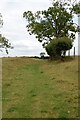
Gagingwell Springs
Marshy land with springs in Gagingwell. There is the plinth of an old cross to the right, and partly obscured by, the weeping willow.
Image: © Rob Farrow
Taken: 17 Apr 2006
0.04 miles
2
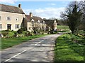
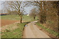
Gagingwell - The lane to Radfordbridge
Lovely Oxfordshire cottages in the hamlet of Gagingwell catch the early evening sunshine on this fine Spring day.
Image: © Rob Farrow
Taken: 17 Apr 2006
0.04 miles
3
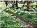
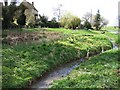
Spring, Pool & Stream : Gagingwell
The title says it all really - except I could add daffodils I suppose !
Image: © Rob Farrow
Taken: 17 Apr 2006
0.04 miles
4
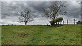
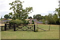
Bridleway heading to Poor Bridge
From Gagingwell the bridleway heading to Poor Bridge
Image: © Shaun Ferguson
Taken: 26 May 2021
0.14 miles