IMAGES TAKEN NEAR TO
OX7 4BZ
Introduction
This page details the photographs taken nearby to OX7 4BZ by members of the Geograph project.
The Geograph project started in 2005 with the aim of publishing, organising and preserving representative images for every square kilometre of Great Britain, Ireland and the Isle of Man.

There are currently over 7.5m images from over14,400 individuals and you can help contribute to the project by visiting https://www.geograph.org.uk
Image Map (Loading...)


Getting Data...Please wait
Leaflet Map data © OpenStreetMap
Images are licensed for reuse under creativecommons.org/licenses/by-sa/2.0
Notes
- Clicking on the map will re-center to the selected point.
- The higher the marker number, the further away the image location is from the centre of the postcode.
Image Listing (6 Images Found)
Images are licensed for reuse under creativecommons.org/licenses/by-sa/2.0
Image
Details
Distance
1
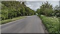
B4030 passing the entrance to Enstone Business Park
B4030 heading to Gagingwell passing the entrance to Enstone Business Park
Image: © Shaun Ferguson
Taken: 26 May 2021
0.11 miles
2

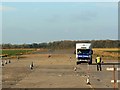
Driver training, Enstone airfield, Oxfordshire
A trainee is receiving one to one instruction on manoeuvring a medium sized van on a runway of this second world war bomber airfield. People often complain about vehicles like these on our roads but remember everything you own was in the back of a truck once.
Image: © Brian Robert Marshall
Taken: 6 Nov 2007
0.17 miles
3
Former runway, Enstone airfield, Oxfordshire
Once upon a time this would have been runway 32 (approximately) given that this is a view to the north-west. The runway is part of what was once a second world war bomber airfield. More here http://www.pixture.co.uk/Airfields/Pages/Enstone.htm Now this part is used for driver training.
Image: © Brian Robert Marshall
Taken: 6 Nov 2007
0.18 miles
4
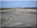
RAF Enstone
RAF Enstone was opened in 1942 as a World War II bomber airfield. It was closed in 1947, and part of it is now in use as an industrial estate. This was one of the two subsidiary runways, this one running in a north-west to south-east direction. Judging by the number of cones around, this part is now used as a driver training area.
Image: © Nigel Cox
Taken: 10 Mar 2007
0.20 miles
5
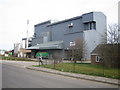
Enstone Airfield Industrial Estate
This grid square is mainly covered by the former RAF Enstone airfield, some areas of which have been turned into an industrial estate. This is ABN (Associated British Nutrition)'s animal feed maufacturing mill.
Image: © Nigel Cox
Taken: 10 Mar 2007
0.21 miles
6
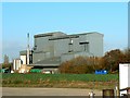
ABN, Enstone, Oxfordshire
This is a view of the rather stark-looking manufacturing premises of ABN (Associated British Nutrition), a subsidiary of Associated British Foods (ABF) PLC, which also owns many well-known brands such as Allinson, Kingsmill and Sunblest breads, Ryvita, Twinings teas and Silver Spoon sugar. Information from http://archive.corporatewatch.org.uk/publications/GEBriefings/abn.html
Image: © Brian Robert Marshall
Taken: 6 Nov 2007
0.25 miles