IMAGES TAKEN NEAR TO
Church End, CHIPPING NORTON, OX7 4BA
Introduction
This page details the photographs taken nearby to Church End, OX7 4BA by members of the Geograph project.
The Geograph project started in 2005 with the aim of publishing, organising and preserving representative images for every square kilometre of Great Britain, Ireland and the Isle of Man.

There are currently over 7.5m images from over14,400 individuals and you can help contribute to the project by visiting https://www.geograph.org.uk
Image Map (Loading...)


Getting Data...Please wait
Leaflet Map data © OpenStreetMap
Images are licensed for reuse under creativecommons.org/licenses/by-sa/2.0
Notes
- Clicking on the map will re-center to the selected point.
- The higher the marker number, the further away the image location is from the centre of the postcode.
Image Listing (85 Images Found)
Images are licensed for reuse under creativecommons.org/licenses/by-sa/2.0
Image
Details
Distance
1
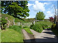
Start of path
Starting alongside the church and running past the motte and bailey castle, the short footpath runs to the bridge over the River Swere.
Image: © Michael Dibb
Taken: 13 May 2012
0.01 miles
2
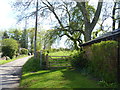
Path leaves road
The footpath leaves the road and heads towards Banbury Road.
Image: © Michael Dibb
Taken: 13 May 2012
0.02 miles
3
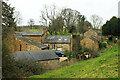
Listed buildings, Swerford
The principal house in the picture, left of centre, is Old Farm Cottage, c 1800 https://historicengland.org.uk/listing/the-list/list-entry/1193917?section=official-list-entry . Extending up the hill right of centre is a terrace of four cottages, Blue Row https://historicengland.org.uk/listing/the-list/list-entry/1052480?section=official-list-entry , seen end on.
Image: © Derek Harper
Taken: 9 Feb 2022
0.02 miles
4
St Mary's Church
St Mary's Church Swerford
Image: © Shaun Ferguson
Taken: 16 Jul 2021
0.02 miles
5

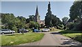
Swerford, St. Mary's Church seen from the eastern approach to the village
Image: © Michael Garlick
Taken: 9 Jun 2017
0.02 miles
6
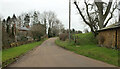
Road past Church End Cottage, Swerford
Church End Cottage is on the left. The road leads to East End.
Image: © Derek Harper
Taken: 9 Feb 2022
0.02 miles
7

Swerford, St. Mary's Church: The altar
Image: © Michael Garlick
Taken: 9 Jun 2017
0.02 miles
8

Swerford, St. Mary's Church: The east window of 1859 ( detail)
Image: © Michael Garlick
Taken: 9 Jun 2017
0.02 miles
9
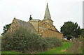
St Mary's church, Swerford
The grade II* listed church is "Late C13. and C15, restored and enlarged 1846 by H.J. Underwood" https://historicengland.org.uk/listing/the-list/list-entry/1193995?section=official-list-entry .
Image: © Derek Harper
Taken: 9 Feb 2022
0.03 miles
10

Swerford, St. Mary's Church: Capital
Image: © Michael Garlick
Taken: 9 Jun 2017
0.03 miles