IMAGES TAKEN NEAR TO
Sturt Close, CHIPPING NORTON, OX7 3SS
Introduction
This page details the photographs taken nearby to Sturt Close, OX7 3SS by members of the Geograph project.
The Geograph project started in 2005 with the aim of publishing, organising and preserving representative images for every square kilometre of Great Britain, Ireland and the Isle of Man.

There are currently over 7.5m images from over14,400 individuals and you can help contribute to the project by visiting https://www.geograph.org.uk
Image Map
Images are licensed for reuse under creativecommons.org/licenses/by-sa/2.0
Notes
- Clicking on the map will re-center to the selected point.
- The higher the marker number, the further away the image location is from the centre of the postcode.
Image Listing (24 Images Found)
Images are licensed for reuse under creativecommons.org/licenses/by-sa/2.0
Image
Details
Distance
2
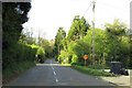
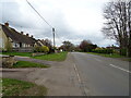
Charlbury: the entrance to Stonesfield Lane
Image: © Andy Stephenson
Taken: 10 Nov 2007
0.10 miles
3
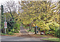
Silver Birches on the Green
A small grassy triangle at the end of Hughes Close.
Image: © Des Blenkinsopp
Taken: 25 Mar 2019
0.10 miles
4
Charlbury Telephone Exchange, Oxon
Situated in Lees Heights, this modern TE serves Charlbury plus Spelsbury nearby. A BT Openreach van can be seen parked in front of the TE to the left of the photo. The numbering ranges of this TE is (01608) 810xxx, 811xxx, the (01608) referring to the Chipping Norton group of TEs, and its postcode is OX7 3EZ.
Image: © David Hillas
Taken: 25 Jul 2009
0.10 miles
5
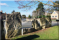
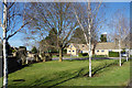
Standing Stones on the Corner
Looking more like a stone age monument than a suburban street corner, these large slabs are at the junction of Hughes Close and Sturt Road.
Image: © Des Blenkinsopp
Taken: 25 Mar 2019
0.11 miles
7
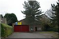
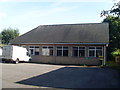
Charlbury fire station
Charlbury fire station, Sturt Road, Charlbury, Oxfordshire, which replaced Image
Image: © Kevin Hale
Taken: 24 Nov 2007
0.12 miles
8
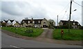
Houses on Woodstock Road, Charlbury
Showing position of Postbox No. OX7 457.
See Image] for postbox.
Image: © JThomas
Taken: 15 Apr 2023
0.12 miles
9

Stonesfield Lane, Charlbury
Stonesfield Lane leads to a bridleway, part of the Oxfordshire Way, which not surprisingly goes to the village of Stonesfield.
Image: © Philip Halling
Taken: 18 Oct 2008
0.14 miles
10
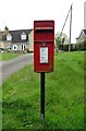
Elizabeth II postbox on Woodstock Road, Charlbury
Postbox No. OX7 457.
See Image] for context.
Image: © JThomas
Taken: 15 Apr 2023
0.15 miles