IMAGES TAKEN NEAR TO
The Playing Close, CHIPPING NORTON, OX7 3QP
Introduction
This page details the photographs taken nearby to The Playing Close, OX7 3QP by members of the Geograph project.
The Geograph project started in 2005 with the aim of publishing, organising and preserving representative images for every square kilometre of Great Britain, Ireland and the Isle of Man.

There are currently over 7.5m images from over14,400 individuals and you can help contribute to the project by visiting https://www.geograph.org.uk
Image Map (Loading...)


Getting Data...Please wait
Leaflet Map data © OpenStreetMap
Images are licensed for reuse under creativecommons.org/licenses/by-sa/2.0
Notes
- Clicking on the map will re-center to the selected point.
- The higher the marker number, the further away the image location is from the centre of the postcode.
Image Listing (169 Images Found)
Images are licensed for reuse under creativecommons.org/licenses/by-sa/2.0
Image
Details
Distance
1
Here they played - Charlbury, Oxfordshire
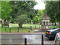
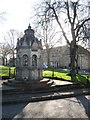
A view of the Playing Close in Charlbury taken from the entrance door of the local Charlbury Co-op (Co-operative) store. This area - the Playing Close - has been set aside for a play area for children since mediaeval times. Towards the end of the 19th century it was used as the site of a market. On the right is the commemorative fountain placed to mark a visit by Queen Victoria. Time taken 2.20 pm BST (British Summer Time).
Image: © Martin Richard Phelan
Taken: 11 Jun 2011
0.02 miles
2
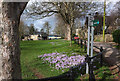
Crocuses, The Playing Close, Charlbury
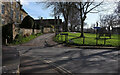
At the eastern corner of the green; the north corner appears in Image The railings are described at https://historicengland.org.uk/listing/the-list/list-entry/1283874?section=official-listing . At the far end of the green is the memorial fountain described at https://historicengland.org.uk/listing/the-list/list-entry/1283841?section=official-listing .
Image: © Derek Harper
Taken: 11 Feb 2022
0.03 miles
3

Egypt, Charlbury
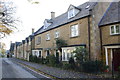
An "C18 or earlier" house overlooking The Playing Close and described at https://historicengland.org.uk/listing/the-list/list-entry/1367840?section=official-list-entry . On the right is Little Egypt Image
Image: © Derek Harper
Taken: 11 Feb 2022
0.03 miles
4
Where children once played - Charlbury, Oxfordshire
The name Charlbury - Ceorl's bury (?) is said to date from Anglo Saxon times. This village beside the River Evenlode once hosted many trades and was a centre of the glove-making industry from the 1800s to the 1960s. There was once an annual fair, held on a number of sites in the village, but this was stopped in 1857 when the proceedings became too rowdy. Sadly the YHA vanished from the place some years ago. In the churchyard is the grave of a man who was killed during the making of the railway 'by a fall of earth in Sydenhams Mead'. The Playing Close has been set aside for children's play since mediaeval times and towards the end of the 19th century was the site of a market. Time photo taken 2.23 pm BST (British Summer Time).
Image: © Martin Richard Phelan
Taken: 11 Jun 2011
0.03 miles
5
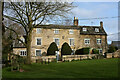
Syccamore House, Charlbury
Overlooking The Playing Close and described at https://historicengland.org.uk/listing/the-list/list-entry/1367819?section=official-list-entry . The garden wall is included in the listing.
Image: © Derek Harper
Taken: 11 Feb 2022
0.04 miles
6
Houses on Pooles Lane
This was the site of the village school, but now retirement housing
Image: © Roger Templeman
Taken: 18 Nov 2014
0.04 miles
7
Winter sunshine in Charlbury
Christmas Day morning 2014, on Enstone Road in centre of Charlbury, the fountain/commemoration to Queen Victoria's visit
Image: © Michael Westley
Taken: 25 Dec 2014
0.04 miles
8
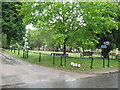
The Playing Close, Charlbury
The north corner of the green. On the left is Sycamore Close https://historicengland.org.uk/listing/the-list/list-entry/1367819?section=official-listing . The C19 iron railings surrounding the green are also listed https://historicengland.org.uk/listing/the-list/list-entry/1283874?section=official-listing .
Image: © Derek Harper
Taken: 11 Feb 2022
0.04 miles
9
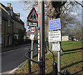
Notices at The Playing Close, Charlbury
Some restrictions apply to how this green is used. Taken a metre or two to the left from Image
Image: © Derek Harper
Taken: 11 Feb 2022
0.04 miles
10

Little Egypt, Charlbury
On Crawborough (carrying bridleway 156 27/10) as it turns to meet The Playing Close.
Image: © Derek Harper
Taken: 11 Feb 2022
0.04 miles