IMAGES TAKEN NEAR TO
Chadlington, CHIPPING NORTON, OX7 3NU
Introduction
This page details the photographs taken nearby to OX7 3NU by members of the Geograph project.
The Geograph project started in 2005 with the aim of publishing, organising and preserving representative images for every square kilometre of Great Britain, Ireland and the Isle of Man.

There are currently over 7.5m images from over14,400 individuals and you can help contribute to the project by visiting https://www.geograph.org.uk
Image Map (Loading...)


Getting Data...Please wait
Leaflet Map data © OpenStreetMap
Images are licensed for reuse under creativecommons.org/licenses/by-sa/2.0
Notes
- Clicking on the map will re-center to the selected point.
- The higher the marker number, the further away the image location is from the centre of the postcode.
Image Listing (16 Images Found)
Images are licensed for reuse under creativecommons.org/licenses/by-sa/2.0
Image
Details
Distance
1
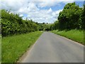
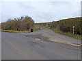
Chipping Norton Road
Chipping Norton Road to the north of Chadlington.
Image: © Philip Halling
Taken: 7 Jun 2017
0.17 miles
2
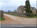
Upper Court Farm Cottages
Seen from the road, these are the last buildings before the land rises onto the bleak 'tops'
Image: © Michael Dibb
Taken: 18 Mar 2012
0.19 miles
3
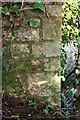
Benchmark on Chipping Norton Road bridge
Ordnance Survey cut mark benchmark described on the Bench Mark Database at http://www.bench-marks.org.uk/bm63112
Image: © Roger Templeman
Taken: 19 Dec 2014
0.19 miles
4
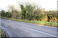
Parapet of bridge behind roadside bushes
There is an OS benchmark Image on the parapet just visible through a gap cut in the bushes near the right hand side of the image
Image: © Roger Templeman
Taken: 19 Dec 2014
0.19 miles
5
Track to the farm
The track, a public footpath, leads off Chipping Norton Road to Curdlehill Farm.
Image: © Michael Dibb
Taken: 18 Mar 2012
0.19 miles
6
![Upper Court Farm [1]](https://s2.geograph.org.uk/geophotos/02/93/84/2938434_60cd3e0b_120x120.jpg)
Upper Court Farm [1]
One of the farm buildings, adorned with solar panels, seen from the road.
Image: © Michael Dibb
Taken: 18 Mar 2012
0.20 miles
7
![Upper Court Farm [2]](https://s2.geograph.org.uk/geophotos/02/93/84/2938442_a6a5e2ca_120x120.jpg)
Upper Court Farm [2]
The farmhouse, seen from the road.
Image: © Michael Dibb
Taken: 18 Mar 2012
0.21 miles
8
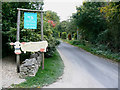
Tite Inn car park entrance, Chadlington
Much as I admire the facsimile of a cow advertising their home-reared beef, I hope they source their beef from prime cattle rather than old cows. The pub itself is round the corner out of sight.
Image: © Brian Robert Marshall
Taken: 30 Sep 2009
0.22 miles
9
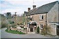
The Tite Inn, Chadlington
This 17th-century pub is on the edge of Chadlington in Oxfordshire, and won Camra's North Oxfordshire pub of the year in 2005: http://www.titeinn.com/. The road visible to the left leads to the A361 and then Churchill.
Image: © SA Mathieson
Taken: 9 Apr 2006
0.22 miles
10
![An inn no more? [2]](https://s1.geograph.org.uk/geophotos/02/93/83/2938385_b1424961_120x120.jpg)
An inn no more? [2]
The steps lead from the car park to the Tite Inn. The signs have gone (see Image) and it is not known whether the pub is closed for refurbishment or whether it is closed for good.
Image: © Michael Dibb
Taken: 18 Mar 2012
0.22 miles