IMAGES TAKEN NEAR TO
Quickset Close, CHIPPING NORTON, OX7 3JW
Introduction
This page details the photographs taken nearby to Quickset Close, OX7 3JW by members of the Geograph project.
The Geograph project started in 2005 with the aim of publishing, organising and preserving representative images for every square kilometre of Great Britain, Ireland and the Isle of Man.

There are currently over 7.5m images from over14,400 individuals and you can help contribute to the project by visiting https://www.geograph.org.uk
Image Map (Loading...)


Getting Data...Please wait
Leaflet Map data © OpenStreetMap
Images are licensed for reuse under creativecommons.org/licenses/by-sa/2.0
Notes
- Clicking on the map will re-center to the selected point.
- The higher the marker number, the further away the image location is from the centre of the postcode.
Image Listing (93 Images Found)
Images are licensed for reuse under creativecommons.org/licenses/by-sa/2.0
Image
Details
Distance
1
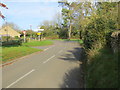
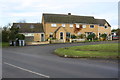
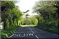
The junction of Taston and Chadlington Roads with the B4026 in Spelsbury
Looking north-eastward along the B4026.
Image: © Peter Wood
Taken: 10 Nov 2017
0.04 miles
2
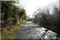
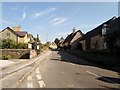
Coming into Spelsbury
On the B4026 from Chipping Norton.
Image: © andrew auger
Taken: 24 Oct 2009
0.04 miles
5
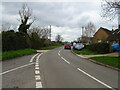
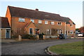
Council Houses, Chadlington Road
Houses appear to have been extended since original build
Image: © Roger Templeman
Taken: 15 Dec 2014
0.07 miles
10
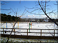
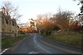
Coloured Jumps
These bright plastic jumps add a bit of colour to this snowy paddock.
Image: © Des Blenkinsopp
Taken: 10 Feb 2010
0.10 miles