IMAGES TAKEN NEAR TO
Taston, CHIPPING NORTON, OX7 3JN
Introduction
This page details the photographs taken nearby to OX7 3JN by members of the Geograph project.
The Geograph project started in 2005 with the aim of publishing, organising and preserving representative images for every square kilometre of Great Britain, Ireland and the Isle of Man.

There are currently over 7.5m images from over14,400 individuals and you can help contribute to the project by visiting https://www.geograph.org.uk
Image Map
Images are licensed for reuse under creativecommons.org/licenses/by-sa/2.0
Notes
- Clicking on the map will re-center to the selected point.
- The higher the marker number, the further away the image location is from the centre of the postcode.
Image Listing (23 Images Found)
Images are licensed for reuse under creativecommons.org/licenses/by-sa/2.0
Image
Details
Distance
1

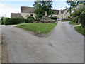
Path to Spelsbury
From Taston the path to Spelsbury heads down the access only drive
Image: © Shaun Ferguson
Taken: 26 May 2021
0.03 miles
2
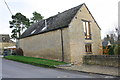
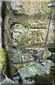
Barn conversion, Taston Road
There is an OS benchmark Image on the road face of the building at the near corner
Image: © Roger Templeman
Taken: 18 Nov 2014
0.05 miles
3

Benchmark on Taston Road building
Ordnance Survey cut mark benchmark described on the Bench Mark Database at http://www.bench-marks.org.uk/bm62156
Image: © Roger Templeman
Taken: 18 Nov 2014
0.05 miles
5
A lane in Taston
The lane splits around a triangle of grass containing the base and broken shaft of a Medieval preaching cross.
Image: © Richard Rogerson
Taken: 7 Jul 2014
0.06 miles
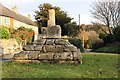
6

Remains of Taston Cross
The base of an old medieval cross stands on a small green in the middle of Taston.
Image: © Des Blenkinsopp
Taken: 4 Sep 2023
0.06 miles
8
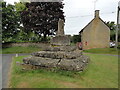
Old Wayside Cross in Taston
Taston Cross, the old shaft, base and steps of a central cross. Set on a grass island in Taston village. Spelsbury parish. Grade II* Listed, details https://historicengland.org.uk/listing/the-list/list-entry/1008407. See also http://www.geograph.org.uk/photo/6620 , https://www.geograph.org.uk/photo/7589143 and https://www.geograph.org.uk/photo/4250875.
Milestone Society National ID: OXWO_SPE01
Image: © Roadside Relics
Taken: 2 Jul 2024
0.06 miles
9

The Standing Stone at Taston
Picture shows the standing stone thought to be a Neolithic Menhir and the Ancient Cross
Image: © michael
Taken: 21 Sep 2008
0.07 miles
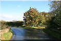
10
Benchmark on 'Brook Cottage'
Ordnance Survey cut mark benchmark described on the Bench Mark Database at http://www.bench-marks.org.uk/bm62119
Image: © Roger Templeman
Taken: 18 Nov 2014
0.11 miles