IMAGES TAKEN NEAR TO
Chilson Hill, CHIPPING NORTON, OX7 3HP
Introduction
This page details the photographs taken nearby to Chilson Hill, OX7 3HP by members of the Geograph project.
The Geograph project started in 2005 with the aim of publishing, organising and preserving representative images for every square kilometre of Great Britain, Ireland and the Isle of Man.

There are currently over 7.5m images from over14,400 individuals and you can help contribute to the project by visiting https://www.geograph.org.uk
Image Map (Loading...)


Getting Data...Please wait
Leaflet Map data © OpenStreetMap
Images are licensed for reuse under creativecommons.org/licenses/by-sa/2.0
Notes
- Clicking on the map will re-center to the selected point.
- The higher the marker number, the further away the image location is from the centre of the postcode.
Image Listing (8 Images Found)
Images are licensed for reuse under creativecommons.org/licenses/by-sa/2.0
Image
Details
Distance
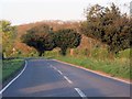
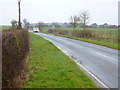
1
Chilson Hill
A short dead-end lane leads to a footpath taking the walker over the hill and into Wychwood Forest.
Image: © Jonathan Billinger
Taken: 16 Mar 2015
0.02 miles
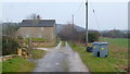
2
Junction with the B4437
Chilson Hill Farm in the background.
Image: © andrew auger
Taken: 29 Dec 2008
0.05 miles
3

Footpath to Wychwood Forest
A little further south-east from Image
Image: © Jonathan Billinger
Taken: 16 Mar 2015
0.05 miles
4
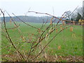
Chilson Hill
Viewed through hazel catkins by the B4437.
Image: © Jonathan Billinger
Taken: 16 Mar 2015
0.05 miles
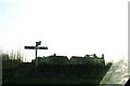
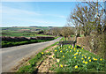
5
Charlbury Road, B4437
Looking east from near the Chilson turn.
Image: © Jonathan Billinger
Taken: 16 Mar 2015
0.08 miles
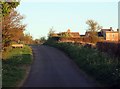
7
The road into Chilson
The road gently slopes down into the Evenlode Valley. It becomes Chilson's single village street before crossing the railway and river a bit further on.
Image: © Des Blenkinsopp
Taken: 25 Mar 2019
0.16 miles