IMAGES TAKEN NEAR TO
Charlbury, CHIPPING NORTON, OX7 3HN
Introduction
This page details the photographs taken nearby to OX7 3HN by members of the Geograph project.
The Geograph project started in 2005 with the aim of publishing, organising and preserving representative images for every square kilometre of Great Britain, Ireland and the Isle of Man.

There are currently over 7.5m images from over14,400 individuals and you can help contribute to the project by visiting https://www.geograph.org.uk
Image Map
Images are licensed for reuse under creativecommons.org/licenses/by-sa/2.0
Notes
- Clicking on the map will re-center to the selected point.
- The higher the marker number, the further away the image location is from the centre of the postcode.
Image Listing (8 Images Found)
Images are licensed for reuse under creativecommons.org/licenses/by-sa/2.0
Image
Details
Distance
1
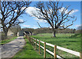
Waterman's Lodge Farm
Some of the few buildings in Wychwood Forest.
Image: © Des Blenkinsopp
Taken: 25 Mar 2019
0.05 miles
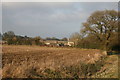
4
Open area, Wychwood Forest
Cultivated fields between areas of woodland.
Image: © Robin Webster
Taken: 18 May 2014
0.17 miles
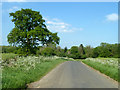
5
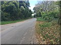
Hatching Lane
Hatching Lane by Waterman's Lodge Farm where the path goes into Wychwood Forest
Image: © Shaun Ferguson
Taken: 14 Oct 2017
0.19 miles
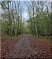
6
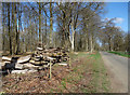
Logs in Shocks Copse
Beside Hatchings Lane.
Image: © Des Blenkinsopp
Taken: 25 Mar 2019
0.19 miles

8
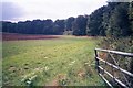
Edge of field within Wychwood Forest
This field is entirely enclosed by Wychwood, a royal and ancient forest. This image is taken from a minor road which runs along a short side to the north-west of the field.
Image: © SA Mathieson
Taken: 20 Aug 2005
0.25 miles