IMAGES TAKEN NEAR TO
Wilcote, CHIPPING NORTON, OX7 3DX
Introduction
This page details the photographs taken nearby to OX7 3DX by members of the Geograph project.
The Geograph project started in 2005 with the aim of publishing, organising and preserving representative images for every square kilometre of Great Britain, Ireland and the Isle of Man.

There are currently over 7.5m images from over14,400 individuals and you can help contribute to the project by visiting https://www.geograph.org.uk
Image Map (Loading...)


Getting Data...Please wait
Leaflet Map data © OpenStreetMap
Images are licensed for reuse under creativecommons.org/licenses/by-sa/2.0
Notes
- Clicking on the map will re-center to the selected point.
- The higher the marker number, the further away the image location is from the centre of the postcode.
Image Listing (12 Images Found)
Images are licensed for reuse under creativecommons.org/licenses/by-sa/2.0
Image
Details
Distance
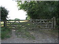
1
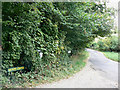
Byway entrance, Wilcote Riding, near Finstock
Signage nearby indicates that the byway is a restricted one. It leads into Topples Wood. The minor road leading away from the viewpoint goes to the hamlet of Wilcote.
Image: © Brian Robert Marshall
Taken: 30 Sep 2009
0.05 miles
2
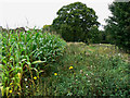
Maize by a byway, near Finstock
The crop isn't quite ready. Usually this crop is destined to be used as cattle fodder.
Image: © Brian Robert Marshall
Taken: 30 Sep 2009
0.05 miles
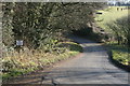
3
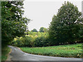
Wilcote Riding, near Finstock
The lane is quite narrow with stopping places. It leads to the hamlet of Wilcote.
Image: © Brian Robert Marshall
Taken: 30 Sep 2009
0.06 miles
4
Sheep by a byway, near Finstock
The byway is restricted according to the signage near the entrance.
Image: © Brian Robert Marshall
Taken: 30 Sep 2009
0.06 miles
5
Field gateway off Wilcote Riding
Image: © Sarah Charlesworth
Taken: 22 Jul 2010
0.07 miles
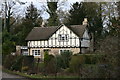
7
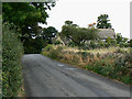
The Ridings, Wilcote Riding, near Finstock
The substantial property is partly in this square but mostly in the next one south. All the road seen here is in this square.
Image: © Brian Robert Marshall
Taken: 30 Sep 2009
0.08 miles
8
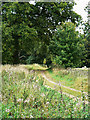
Byway, near Finstock
The byway, which is restricted, runs through Topples Wood and in a semi-circle to Finstock, west of here.
Image: © Brian Robert Marshall
Taken: 30 Sep 2009
0.08 miles
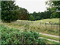
10
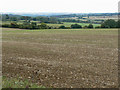
Farmland east of Finstock
Not very inspiring-looking at this time of year. It will undoubtedly look better when the crop has grown.
Image: © Brian Robert Marshall
Taken: 30 Sep 2009
0.14 miles