IMAGES TAKEN NEAR TO
Wilcote, CHIPPING NORTON, OX7 3DT
Introduction
This page details the photographs taken nearby to OX7 3DT by members of the Geograph project.
The Geograph project started in 2005 with the aim of publishing, organising and preserving representative images for every square kilometre of Great Britain, Ireland and the Isle of Man.

There are currently over 7.5m images from over14,400 individuals and you can help contribute to the project by visiting https://www.geograph.org.uk
Image Map (5 Images)


Getting Data...Please wait
Leaflet Map data © OpenStreetMap
Images are licensed for reuse under creativecommons.org/licenses/by-sa/2.0
Notes
- Clicking on the map will re-center to the selected point.
- The higher the marker number, the further away the image location is from the centre of the postcode.
Image Listing (5 Images Found)
Images are licensed for reuse under creativecommons.org/licenses/by-sa/2.0
Image
Details
Distance
1
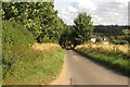
The road past Bridewell Farm Cottages
Image: © Steve Daniels
Taken: 18 Aug 2013
0.16 miles
2
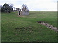
Lady Well Spring
Lady Well Spring the head within the confines of the stone walls
Image: © Shaun Ferguson
Taken: 7 Jan 2012
0.21 miles
3
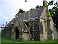
St Peters Church, Wilcote
This is St Peters Church in the small hamlet of Wilcote. Currently there is work underway to repair the Stonesfield Slate tiled roof. Very small church hardly used.
Image: © neil hanson
Taken: 3 May 2005
0.23 miles
4
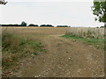
More farmland near Bridewell Farm Cottages, East End, Witney
If this field has been sown it doesn't show yet. It lies to the north of the cottages.
Image: © Brian Robert Marshall
Taken: 30 Sep 2009
0.25 miles
