IMAGES TAKEN NEAR TO
Lower End, CHIPPING NORTON, OX7 3AZ
Introduction
This page details the photographs taken nearby to Lower End, OX7 3AZ by members of the Geograph project.
The Geograph project started in 2005 with the aim of publishing, organising and preserving representative images for every square kilometre of Great Britain, Ireland and the Isle of Man.

There are currently over 7.5m images from over14,400 individuals and you can help contribute to the project by visiting https://www.geograph.org.uk
Image Map (Loading...)


Getting Data...Please wait
Leaflet Map data © OpenStreetMap
Images are licensed for reuse under creativecommons.org/licenses/by-sa/2.0
Notes
- Clicking on the map will re-center to the selected point.
- The higher the marker number, the further away the image location is from the centre of the postcode.
Image Listing (10 Images Found)
Images are licensed for reuse under creativecommons.org/licenses/by-sa/2.0
Image
Details
Distance
1
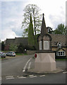
Ramsden Memorial and Church
View of the Ramsden War Memorial located in the centre of the village, with St James Church in the background.
Image: © neil hanson
Taken: 1 May 2005
0.11 miles


4
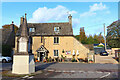
The Royal Oak
Pub and war memorial in Ramsden.
Image: © Wayland Smith
Taken: 30 Oct 2021
0.12 miles

6

Wilcote Lane
Wilcote Lane looking to St Jame's Church Ramsden
Image: © Shaun Ferguson
Taken: 22 Jan 2012
0.13 miles