IMAGES TAKEN NEAR TO
Stonor Green, WATLINGTON, OX49 5PT
Introduction
This page details the photographs taken nearby to Stonor Green, OX49 5PT by members of the Geograph project.
The Geograph project started in 2005 with the aim of publishing, organising and preserving representative images for every square kilometre of Great Britain, Ireland and the Isle of Man.

There are currently over 7.5m images from over14,400 individuals and you can help contribute to the project by visiting https://www.geograph.org.uk
Image Map
Images are licensed for reuse under creativecommons.org/licenses/by-sa/2.0
Notes
- Clicking on the map will re-center to the selected point.
- The higher the marker number, the further away the image location is from the centre of the postcode.
Image Listing (36 Images Found)
Images are licensed for reuse under creativecommons.org/licenses/by-sa/2.0
Image
Details
Distance
1
Watlington: Former watercress bed
This non-descript dry (in December 2013) pond off Spring Lane is immediately downstream of a spring at the foot of the Chilterns. Old Ordnance Survey maps show that the pond was almost certainly dug out to create a short-lived watercress bed, and it is marked as such on the map of 1898. By the time that the 1921 edition was produced the pond was well-defined but the descriptive text had been removed.
Image: © Nigel Cox
Taken: 8 Dec 2013
0.06 miles
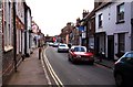
3
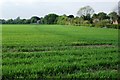
Fields on the southern edge of Watlington
Looking north from the footpath between Howe Road and Lys Farm.
Image: © Simon Mortimer
Taken: 4 May 2010
0.13 miles
5
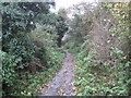
Watlington: Footpath towards Springfield Farm
This footpath leads off Spring Lane south-eastwards towards Springfield Farm and the B480 Howe Road.
Image: © Nigel Cox
Taken: 8 Dec 2013
0.14 miles
6
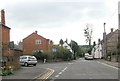
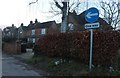
Couching Street junction from Brook Street
Image: © John Firth
Taken: 4 Apr 2014
0.15 miles
7

Riding the Evening Breeze: Red kite over Watlington, Oxfordshire
Milvus milvus is getting very common in these parts as at the beginning of 2014. One of the locals told me that around here they are known as the "Watlington sparrow".
Image: © Edmund Shaw
Taken: 2 Feb 2014
0.15 miles
8
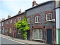
Watlington - Market Town
Couching Street, brick buildings with old signwork - kitchen, chandler.
Image: © Colin Smith
Taken: 16 Aug 2016
0.16 miles
10
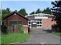
Watlington Telephone Exchange, Oxon
Situated in Spring Lane near Hill Road, this TE, which has the code THWT, is in the background and would have replaced the standard dark wooden hut at the front, possibly in the 1970s when several of the larger TEs were built to handle increased telephone traffic. It provides telephone and broadband services to 1,519 residential and 105 non-residential premises in Watlington, plus Brightwell Baldwin, Britwell Salome, Christmas Common, Cuxham, Pyrton and Shirburn nearby. This TE has (01491) 61xxxx numbers, the (01491) referring to the Henley-on-Thames group of ten TEs, and its postcode is OX49 5BD.
Image: © David Hillas
Taken: 8 Aug 2009
0.18 miles