IMAGES TAKEN NEAR TO
Brightwell Baldwin, WATLINGTON, OX49 5PN
Introduction
This page details the photographs taken nearby to OX49 5PN by members of the Geograph project.
The Geograph project started in 2005 with the aim of publishing, organising and preserving representative images for every square kilometre of Great Britain, Ireland and the Isle of Man.

There are currently over 7.5m images from over14,400 individuals and you can help contribute to the project by visiting https://www.geograph.org.uk
Image Map
Images are licensed for reuse under creativecommons.org/licenses/by-sa/2.0
Notes
- Clicking on the map will re-center to the selected point.
- The higher the marker number, the further away the image location is from the centre of the postcode.
Image Listing (1 Images Found)
Images are licensed for reuse under creativecommons.org/licenses/by-sa/2.0
Image
Details
Distance
1
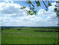
New Trees
I guess when these newly planted trees grow up this view will be gone.
This is what it looks like from up here, grass and grain as far as you can see.
Wittenham Clumps and Didcot power station on the horizon.
Image: © Des Blenkinsopp
Taken: 28 May 2010
0.20 miles