IMAGES TAKEN NEAR TO
Upperton, WATLINGTON, OX49 5PD
Introduction
This page details the photographs taken nearby to Upperton, OX49 5PD by members of the Geograph project.
The Geograph project started in 2005 with the aim of publishing, organising and preserving representative images for every square kilometre of Great Britain, Ireland and the Isle of Man.

There are currently over 7.5m images from over14,400 individuals and you can help contribute to the project by visiting https://www.geograph.org.uk
Image Map
Images are licensed for reuse under creativecommons.org/licenses/by-sa/2.0
Notes
- Clicking on the map will re-center to the selected point.
- The higher the marker number, the further away the image location is from the centre of the postcode.
Image Listing (6 Images Found)
Images are licensed for reuse under creativecommons.org/licenses/by-sa/2.0
Image
Details
Distance
1
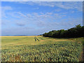
Farmland, Brightwell Baldwin
A field of wheat to the east of the road at Upperton.
Image: © Andrew Smith
Taken: 8 Jul 2009
0.06 miles

3
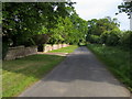
Lane to Brightwell Baldwin
Lane to Brightwell Baldwin by The Old School House
Image: © Shaun Ferguson
Taken: 20 May 2009
0.08 miles
5
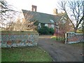
The Old School House
Now a private residence.
Image: © Colin Bates
Taken: 19 Dec 2005
0.19 miles
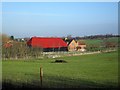
6
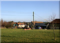
Upperton Farm
Upperton only has a handful of houses, mostly around this large green.
Image: © Des Blenkinsopp
Taken: 18 Jan 2011
0.21 miles