IMAGES TAKEN NEAR TO
Brightwell Baldwin, WATLINGTON, OX49 5NX
Introduction
This page details the photographs taken nearby to OX49 5NX by members of the Geograph project.
The Geograph project started in 2005 with the aim of publishing, organising and preserving representative images for every square kilometre of Great Britain, Ireland and the Isle of Man.

There are currently over 7.5m images from over14,400 individuals and you can help contribute to the project by visiting https://www.geograph.org.uk
Image Map
Images are licensed for reuse under creativecommons.org/licenses/by-sa/2.0
Notes
- Clicking on the map will re-center to the selected point.
- The higher the marker number, the further away the image location is from the centre of the postcode.
Image Listing (11 Images Found)
Images are licensed for reuse under creativecommons.org/licenses/by-sa/2.0
Image
Details
Distance
4
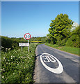
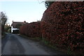
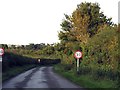
30 mph in Brightwell Baldwin
The Brightwell part of the name is ancient, going back to Saxon times, and is quite common in this area of abundant spring sources. Baldwin is a family name added on later by lords of the manor.
Image: © Des Blenkinsopp
Taken: 25 Apr 2020
0.10 miles

10
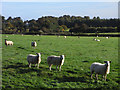
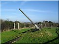
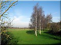
Pasture, Brightwell Baldwin
Sheep in morning sunshine to the south of the village.
Image: © Andrew Smith
Taken: 2 Oct 2010
0.22 miles