IMAGES TAKEN NEAR TO
Cuxham Road, WATLINGTON, OX49 5NA
Introduction
This page details the photographs taken nearby to Cuxham Road, OX49 5NA by members of the Geograph project.
The Geograph project started in 2005 with the aim of publishing, organising and preserving representative images for every square kilometre of Great Britain, Ireland and the Isle of Man.

There are currently over 7.5m images from over14,400 individuals and you can help contribute to the project by visiting https://www.geograph.org.uk
Image Map
Images are licensed for reuse under creativecommons.org/licenses/by-sa/2.0
Notes
- Clicking on the map will re-center to the selected point.
- The higher the marker number, the further away the image location is from the centre of the postcode.
Image Listing (4 Images Found)
Images are licensed for reuse under creativecommons.org/licenses/by-sa/2.0
Image
Details
Distance
1
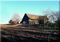
Glebe Barn near Watlington
This old thatched timber barn is converted for business use now.
Image: © Des Blenkinsopp
Taken: 27 Jan 2012
0.06 miles
2
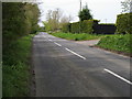
The B480 heading to Cuxham
The B480 heading to Cuxham passing Glebe Farm
Image: © Shaun Ferguson
Taken: 3 May 2008
0.10 miles
4
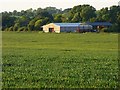
Farmland and barns, Watlington
The land here is often used for rearing pigs, but on this occasion they were some distance to the west.
Image: © Andrew Smith
Taken: 28 May 2019
0.23 miles