IMAGES TAKEN NEAR TO
Hamstyles, WATLINGTON, OX49 5LP
Introduction
This page details the photographs taken nearby to Hamstyles, OX49 5LP by members of the Geograph project.
The Geograph project started in 2005 with the aim of publishing, organising and preserving representative images for every square kilometre of Great Britain, Ireland and the Isle of Man.

There are currently over 7.5m images from over14,400 individuals and you can help contribute to the project by visiting https://www.geograph.org.uk
Image Map
Images are licensed for reuse under creativecommons.org/licenses/by-sa/2.0
Notes
- Clicking on the map will re-center to the selected point.
- The higher the marker number, the further away the image location is from the centre of the postcode.
Image Listing (38 Images Found)
Images are licensed for reuse under creativecommons.org/licenses/by-sa/2.0
Image
Details
Distance
1
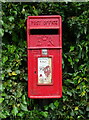
Elizabeth II postbox on the B4009, Britwell Salome
Postbox No. OX49 484.
Image: © JThomas
Taken: 25 May 2022
0.02 miles
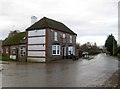
2
The Old Red Lion car park, Britwell Salome
It's called Olivier now but the Red Lion Farm is still next to it.
Image: © David Howard
Taken: 12 Jan 2020
0.03 miles
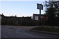
3
Turner's Green
A specific part of Britwell Salome, where the bridleway from Brightwell Baldwin, used by Shakespeare's Way, meets the B4009, in the foreground.
Image: © Graham Horn
Taken: 4 May 2013
0.03 miles
5
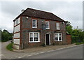
The Red Lion, Britwell Salome
On the B4009.
Incorporates Olivier at The Red Lion restaurant.
See Image] for sign.
Image: © JThomas
Taken: 25 May 2022
0.04 miles
6
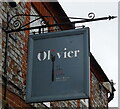
Sign for the Olivier at The Red Lion
See Image] for context.
Image: © JThomas
Taken: 25 May 2022
0.04 miles
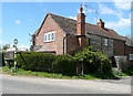
7
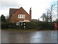
Britwell Salome: The Red Lion
Well, Image submitted by Des appears to be well and truly cooked, as the pub has now reverted to its traditional name and function. It is a Grade II Listed building, one of several in the village. The English Heritage website describes it thus:-
"Inn, now public house. Late C18/early C19. Front of header bond grey brick with red brick dressings; sides and rear of colourwashed chalk with brick dressings; hipped old tile roof; brick rear lateral stacks. L-plan with rear left wing. 2 storeys; 3-window range. Pedimented doorway to 6-panelled (2 glazed) door, flanked by canted bays with horned sashes. Gauged brick flat arches over 6-pane sashes. Red brick eaves band and dentilled eaves. Late C18 rear wing of one-storey and attic, 2-window range: chalk and flint rubble with brick dressings, gabled old tile roof and brick internal stack; 6-panelled door, C20 bay window and horizontal-sliding sash. C19 brick rear bay. Interior not inspected. The Tithe Commissioners met here in 1841."
The road in front is the B4009.
Image: © Nigel Cox
Taken: 8 Dec 2013
0.04 miles
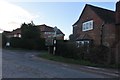
10
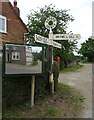
Britwell Salome: Oxfordshire County Council fingerpost sign
This old Oxfordshire County Council fingerpost sign is on the B4009 at its junction with the road to Britwell Hill. The sign reads "Ewelme 2, Benson 3¼" to the left, "Watlington 1½" to the right, and "Britwell Hill 1¾" towards the photographer. The mirrors at the side of the sign are essential for traffic coming out of the side lane as the visibility splay is non-existent along the B4009 in both directions...
Image: © Nigel Cox
Taken: 8 Dec 2013
0.04 miles