IMAGES TAKEN NEAR TO
Britwell Salome, WATLINGTON, OX49 5LD
Introduction
This page details the photographs taken nearby to OX49 5LD by members of the Geograph project.
The Geograph project started in 2005 with the aim of publishing, organising and preserving representative images for every square kilometre of Great Britain, Ireland and the Isle of Man.

There are currently over 7.5m images from over14,400 individuals and you can help contribute to the project by visiting https://www.geograph.org.uk
Image Map
Images are licensed for reuse under creativecommons.org/licenses/by-sa/2.0
Notes
- Clicking on the map will re-center to the selected point.
- The higher the marker number, the further away the image location is from the centre of the postcode.
Image Listing (79 Images Found)
Images are licensed for reuse under creativecommons.org/licenses/by-sa/2.0
Image
Details
Distance
1
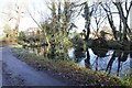
Pond near Lower Farm
Appears to be more for drainage than a pond but does make a reasonable scene.
Image: © Bill Nicholls
Taken: 2 Dec 2012
0.04 miles
2
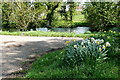
Pond at Lower Farm
This pond forms part of an extensive drainage pattern at Lower Farm. Shakespeare's Way passes.
Image: © Graham Horn
Taken: 4 May 2013
0.05 miles
3

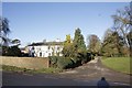
Britwell House
Built in 1728 for Sir Edward Simeon.
Image: © Des Blenkinsopp
Taken: 9 Aug 2010
0.05 miles
4
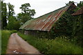
Barn near the church, Britwell Salome
The corrugated iron roof is obviously much later than the wavy wooden walls of this long barn.
Image: © Christopher Hilton
Taken: 28 May 2017
0.06 miles
5

View across fields to a mock-castle, Britwell Salome
Image: © Christopher Hilton
Taken: 28 May 2017
0.07 miles
6
Clock on the wall
Rather nice little feature of the farm by Britwell House is the clock on the wall.
Image: © Bill Nicholls
Taken: 2 Dec 2012
0.07 miles
7
Road to St Nicholas
The road leading to St Nicholas church in Britwell Salome with Britwell house on the left. I remember seeing Topiary hedges here when I was young but these have sadly gone.
Image: © Bill Nicholls
Taken: 2 Dec 2012
0.07 miles
8
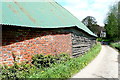
Barn at Lower Farm
Shakespeare's Way passes this lovely barn, with Flemish bond brickwork, wooden cladding and a metal roof. The track leads towards St. Nicholas's church.
Image: © Graham Horn
Taken: 4 May 2013
0.07 miles
9
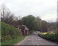
B4009 at The Priory
Lane to church at bottom of hill
Image: © John Firth
Taken: 4 Apr 2014
0.07 miles
10
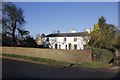
Britwell House
Britwell House a place I remember going past as a child in my dads car, always thought it a nice looking place. for a better view see Image
Image: © Bill Nicholls
Taken: 2 Dec 2012
0.07 miles