IMAGES TAKEN NEAR TO
Christmas Common, WATLINGTON, OX49 5HU
Introduction
This page details the photographs taken nearby to OX49 5HU by members of the Geograph project.
The Geograph project started in 2005 with the aim of publishing, organising and preserving representative images for every square kilometre of Great Britain, Ireland and the Isle of Man.

There are currently over 7.5m images from over14,400 individuals and you can help contribute to the project by visiting https://www.geograph.org.uk
Image Map
Images are licensed for reuse under creativecommons.org/licenses/by-sa/2.0
Notes
- Clicking on the map will re-center to the selected point.
- The higher the marker number, the further away the image location is from the centre of the postcode.
Image Listing (8 Images Found)
Images are licensed for reuse under creativecommons.org/licenses/by-sa/2.0
Image
Details
Distance
1
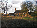
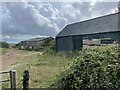
Portobello Farm, Christmas Common
This farm lies next to the 500m section of road that affords the only public access to SU7294
Image: © David Ellis
Taken: 21 Jan 2006
0.03 miles
2
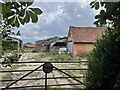
Farmyard at Portobello Farm, Shirburn
Image: © Simon Mortimer
Taken: 7 Sep 2022
0.07 miles
3
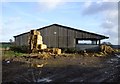
Barn at Portobello Farm, Shirburn
A muddy farmyard with cattle ensconced for the winter.
Image: © Andrew Smith
Taken: 22 Dec 2018
0.08 miles
6
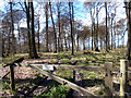
Not In My Woods....
A lot of Chiltern woodlands are remarkably well provided with footpaths, but the forested scarp of Shirburn Wood remains resolutely unwelcoming.
Image: © Des Blenkinsopp
Taken: 26 Apr 2013
0.20 miles
7
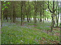
Shirburn Wood
The edge of Shirburn Wood by Portobello Farm
Image: © Shaun Ferguson
Taken: 17 May 2009
0.21 miles
8
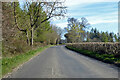
Road towards Chinnor
Running along the crest of the Chilterns at around a height of 250 m.
Image: © Robin Webster
Taken: 18 Apr 2021
0.25 miles