IMAGES TAKEN NEAR TO
Greenfield, WATLINGTON, OX49 5HF
Introduction
This page details the photographs taken nearby to Greenfield, OX49 5HF by members of the Geograph project.
The Geograph project started in 2005 with the aim of publishing, organising and preserving representative images for every square kilometre of Great Britain, Ireland and the Isle of Man.

There are currently over 7.5m images from over14,400 individuals and you can help contribute to the project by visiting https://www.geograph.org.uk
Image Map
Images are licensed for reuse under creativecommons.org/licenses/by-sa/2.0
Notes
- Clicking on the map will re-center to the selected point.
- The higher the marker number, the further away the image location is from the centre of the postcode.
Image Listing (7 Images Found)
Images are licensed for reuse under creativecommons.org/licenses/by-sa/2.0
Image
Details
Distance
1
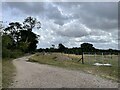
Farm track near Lower Greenfield Farm
Looking south-east from Christmas Common Road towards Greenfield Wood.
Image: © Simon Mortimer
Taken: 7 Sep 2022
0.03 miles
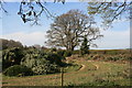
2
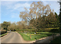
Road by Greenfield Manor (springtime)
Just for comparison with Andrew's icy picture of the same place Image
Image: © Des Blenkinsopp
Taken: 31 Mar 2014
0.04 miles
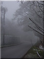
3
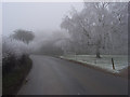
Road at Greenfield Manor
Freezing fog had rendered a birch rather more silvery than usual.
Image: © Andrew Smith
Taken: 23 Dec 2006
0.05 miles
4
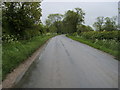
Road entering Greenfield
The road to Christmas Common entering Greenfield
Image: © Shaun Ferguson
Taken: 17 May 2009
0.07 miles
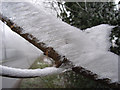
5
Frost on a twig
The roadside near Greenfield Manor following freezing fog but not snow.
Image: © Andrew Smith
Taken: 23 Dec 2006
0.09 miles
6
Road near Greenfield Manor
Frost, not snow, resulting from the freezing fog.
Image: © Andrew Smith
Taken: 23 Dec 2006
0.09 miles
7
No Happy Christmas for These
Greenfield Farm is a big centre for Christmas Tree growing and selling.
These ones have been cut down a bit out of season by the look.
Image: © Des Blenkinsopp
Taken: 31 Mar 2014
0.23 miles