IMAGES TAKEN NEAR TO
Howe Road, WATLINGTON, OX49 5ET
Introduction
This page details the photographs taken nearby to Howe Road, OX49 5ET by members of the Geograph project.
The Geograph project started in 2005 with the aim of publishing, organising and preserving representative images for every square kilometre of Great Britain, Ireland and the Isle of Man.

There are currently over 7.5m images from over14,400 individuals and you can help contribute to the project by visiting https://www.geograph.org.uk
Image Map
Images are licensed for reuse under creativecommons.org/licenses/by-sa/2.0
Notes
- Clicking on the map will re-center to the selected point.
- The higher the marker number, the further away the image location is from the centre of the postcode.
Image Listing (13 Images Found)
Images are licensed for reuse under creativecommons.org/licenses/by-sa/2.0
Image
Details
Distance
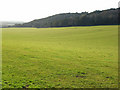
3
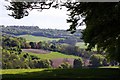
View into the Lower Dean valley from Watlington Hill
The dark trees in the foreground are part of the yew woodland at Watlington Hill, one of the few examples of this type of woodland in the Chilterns.
Image: © Simon Mortimer
Taken: 23 Feb 2009
0.07 miles
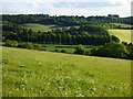
4
Hillside above Watlington
A strip of maize stubble, last year's gamebird cover, alongside a strip of woodland above Lower Dean Farm.
Image: © Andrew Smith
Taken: 30 Mar 2008
0.11 miles
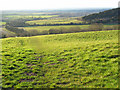
5
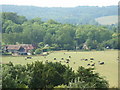
Pasture, Watlington
Looking across to woodland on the southern side of Watlington Hill from the edge of Lower Dean Wood.
Image: © Andrew Smith
Taken: 30 Mar 2008
0.14 miles
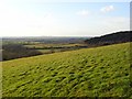
6
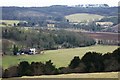
Hillside above Watlington
The track in the grass here is the footpath descending from Watlington Park. In this view from the Chiltern escarpment we see the town of Watlington behind the wooded western end of Watlington Hill. Flat country stretches towards Oxford.
Image: © Andrew Smith
Taken: 30 Mar 2008
0.17 miles
7
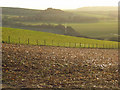
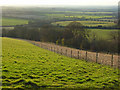
Hillside above Watlington
Looking towards The Howe over maize stubble and pasture.
Image: © Andrew Smith
Taken: 30 Mar 2008
0.19 miles
8
Pasture, Watlington
A view towards Britwell Hill from the footpath below Watlington Park.
Image: © Andrew Smith
Taken: 28 May 2019
0.20 miles
9
Hillside above Watlington
Lush improved grassland in evening sunshine. The town of Watlington can be seen in the centre of the picture.
Image: © Andrew Smith
Taken: 30 Mar 2008
0.20 miles
10
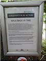
National Trust Notice at Watlington Hill
This notice is located at the south-west edge of Watlington Hill by a bridleway. It has the following wording:
CONSERVATION IN ACTION
WALK BACK IN TIME
In the Winter of 2006, work started opening up this ancient track way.
This stretch of the feature, which is also known as a sunken way or hollow way is approximately 400m in length, and in its time would have been the modern equivalent of a main 'road'. Virtually the whole project has been achieved by volunteer effort.
The Sonning Common Green Gym volunteers set themselves the mammoth task of clearing the archaeological features as part of the 'Oxford Inspires 2007' celebrations (which commemorated 1,000 years of the county of Oxfordshire's existence).
With occasional assistance from other volunteer groups (Friends of Watlington Hill and Oxford Conservation Volunteers); the work has now been completed.
There were three aims to the project:-
1. Open up the archaeological feature so that it could once again be used as a walkway.
2. By using the 'sunken' way as an alternative route, visitors will reduce the wear and tear on the existing path (now showing signs of erosion) which lies on the very high quality chalk grassland.
3. In cutting back many of the large, low branches from the Yew trees, we have regained a large strip of land between the existing path and the 'sunken' way. This area would have been flower rich chalk grassland 30-40 years ago before the dense shade of the Yews killed it off. In time, it should return to this condition, thus benefiting the many butterflies and wild flowers that can be found on this species rich habitat.
So, please consider using this 'new' old track way as an alternative route and in doing so help to preserve the archaeological feature as well as the grassland habitat for years to come.
With particular thanks to Sonning Common Gym for all their hard work and to all the volunteers who helped complete the task.
Image: © David Hillas
Taken: 27 Aug 2018
0.20 miles