IMAGES TAKEN NEAR TO
WATLINGTON, OX49 5EQ
Introduction
This page details the photographs taken nearby to OX49 5EQ by members of the Geograph project.
The Geograph project started in 2005 with the aim of publishing, organising and preserving representative images for every square kilometre of Great Britain, Ireland and the Isle of Man.

There are currently over 7.5m images from over14,400 individuals and you can help contribute to the project by visiting https://www.geograph.org.uk
Image Map
Images are licensed for reuse under creativecommons.org/licenses/by-sa/2.0
Notes
- Clicking on the map will re-center to the selected point.
- The higher the marker number, the further away the image location is from the centre of the postcode.
Image Listing (4 Images Found)
Images are licensed for reuse under creativecommons.org/licenses/by-sa/2.0
Image
Details
Distance
1
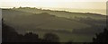
Velvet green hills seen from Watlington Hill, Oxfordshire
Taken a little higher up the hill from Image
Image: © Edmund Shaw
Taken: 2 Feb 2014
0.09 miles
2
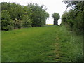
Footpath to Watlington
Footpath to Watlington by Lys Farm
Image: © Shaun Ferguson
Taken: 17 May 2009
0.15 miles
3
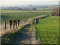
Farmland and footpath, Watlington
A gradual descent on the eastern side of Cobditch Hill.
Image: © Andrew Smith
Taken: 24 Feb 2019
0.22 miles
4
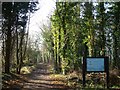
Ridgeway, Swan's Way & Icknield Way
Once the Icknield Way, Icknield House is close by, it is now part of the Swan's Way, and Ridgeway routes.
Image: © Colin Bates
Taken: 19 Dec 2005
0.25 miles