IMAGES TAKEN NEAR TO
Hampdens Way, OX49 5EE
Introduction
This page details the photographs taken nearby to Hampdens Way, OX49 5EE by members of the Geograph project.
The Geograph project started in 2005 with the aim of publishing, organising and preserving representative images for every square kilometre of Great Britain, Ireland and the Isle of Man.

There are currently over 7.5m images from over14,400 individuals and you can help contribute to the project by visiting https://www.geograph.org.uk
Image Map
Images are licensed for reuse under creativecommons.org/licenses/by-sa/2.0
Notes
- Clicking on the map will re-center to the selected point.
- The higher the marker number, the further away the image location is from the centre of the postcode.
Image Listing (9 Images Found)
Images are licensed for reuse under creativecommons.org/licenses/by-sa/2.0
Image
Details
Distance
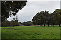
2
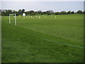
Watlington Sports Ground
Watlington Sports Ground football pitch and cricket match
Image: © Shaun Ferguson
Taken: 3 May 2008
0.14 miles
4

Parkland, Pyrton
Cattle grazing in the parkland of the Shirburn Estate beside the road into Pyrton from the B4009.
Image: © Andrew Smith
Taken: 25 Sep 2011
0.15 miles
5
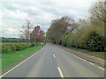
B4009 enters Watlington
The B4009 has changed its identity since the M40 transit. It is now called the Shirburn Road.
Image: © Stuart Logan
Taken: 8 Apr 2012
0.15 miles
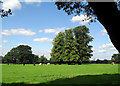
6
Parkland at Shirburn Castle
The parkland around Shirburn Castle was laid out between 1780 and 1807 and includes clumps and lines of holm oak.
Image: © Simon Mortimer
Taken: 4 Apr 2019
0.15 miles
7
Shirburn Park
This is pretty representative of the whole area between Shirburn and the road to Pyrton.
Image: © Des Blenkinsopp
Taken: 1 Sep 2010
0.17 miles
8
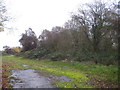
Pyrton: Former Watlington railway station (1)
Just visible through the trees are the surviving chimney stacks of the otherwise derelict station building. The open area in front was the former approach to the station and its goods yard.
This was the terminus of the single track line from Princes Risborough, opened in 1872 and closed here at least by British Railways in 1957. The section from Chinnor northwards to Princes Risborough remained open for the cement works traffic originally and remains open as a heritage railway today. It was originally intended to extend the line from Watlington to Wallingford to create a link between Cholsey on the Great Western Main Line and Princes Risborough, but the connection was never made because of financial constraints.
The station is some way out of Watlington and actually in the neighbouring parish of Pyrton. If the connection to Wallingford had been made the station here would undoubtedly have been moved southwards to be nearer Watlington. Some idea of the lack of traffic on the line can be judged by the fact that in its 85 years of existence few if any houses were built near the station, and it remained as isolated when it closed as it was when it was opened. Apart from the overgrown buildings the only other reminder of its existence is the Station Road name of the lane leading to it.
Image: © Nigel Cox
Taken: 8 Dec 2013
0.17 miles
9
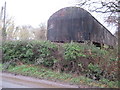
Pyrton: Former Watlington railway station (2)
Please see Image for details of the station.
This long corrugated shed was evidently part of the station infrastructure, possibly as a carriage shed for the terminus of the line, or possibly as a goods shed, although such a facility certainly existed on the other side of the station. More than 50 years after the station was closed completely to goods traffic at the start of 1961, and remembering that it would not have been new then, the shed roof remains in remarkably good condition.
Image: © Nigel Cox
Taken: 8 Dec 2013
0.18 miles