IMAGES TAKEN NEAR TO
Mafeking Row, WATLINGTON, OX49 5DW
Introduction
This page details the photographs taken nearby to Mafeking Row, OX49 5DW by members of the Geograph project.
The Geograph project started in 2005 with the aim of publishing, organising and preserving representative images for every square kilometre of Great Britain, Ireland and the Isle of Man.

There are currently over 7.5m images from over14,400 individuals and you can help contribute to the project by visiting https://www.geograph.org.uk
Image Map
Images are licensed for reuse under creativecommons.org/licenses/by-sa/2.0
Notes
- Clicking on the map will re-center to the selected point.
- The higher the marker number, the further away the image location is from the centre of the postcode.
Image Listing (20 Images Found)
Images are licensed for reuse under creativecommons.org/licenses/by-sa/2.0
Image
Details
Distance
1
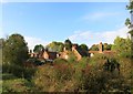
The Back of Blenheim Road
Evening sun on the backs of houses in Blenheim Road, Shirburn's short village street.
Image: © Des Blenkinsopp
Taken: 7 Oct 2014
0.03 miles
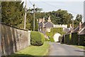
2
Blenheim Road, Shirburn
Shirburn village is owned by the Shirburn Estate and the whole place has a bit of a Days Gone By look to it.
The estate has a reputation locally for being rather secretive, which ongoing feuding within the owning family hasn't helped.
There is no access to most of the square except just here, and a short bit of the Ridgeway in the other corner.
Image: © Des Blenkinsopp
Taken: 7 Oct 2014
0.04 miles
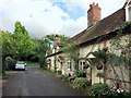
3

Shirburn: Blenheim Road
This block of seven cottages was built for workers on the Shirburn estate and dates from around 1800. The whole block is a Grade II Listed Building.
Image: © Nigel Cox
Taken: 8 Dec 2013
0.05 miles
4

Blenheim Road Shirburn
Cottages on Blenheim Road Shirburn
Image: © Shaun Ferguson
Taken: 3 May 2008
0.05 miles
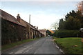
5
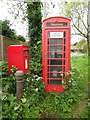
K6 Telephone Box and Post Box in Shirburn
Situated in Blenheim Road OX49 5DN, this red telephone box has a notice mentioning that coins are not accepted by the payphone inside. To the left of the photo is the red post box on a post which is hidden by the large iron post in front of it.
Image: © David Hillas
Taken: 12 May 2017
0.09 miles
6
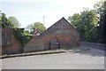
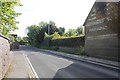
Castle Road
Looking towards one of the old farm buildings on the corner of Castle Road in Shirburn.
Image: © Bill Nicholls
Taken: 26 May 2013
0.10 miles
7
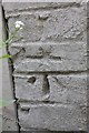
Shirburn benchmark
Close-up of the benchmark on the roadside cottage in Shirburn Image
Image: © Bill Nicholls
Taken: 26 May 2013
0.11 miles
8
Watlington Road
Where it passes the road junction of castle road in Shirburn, just over to the right on the end of the building is a benchmark
Image: © Bill Nicholls
Taken: 26 May 2013
0.11 miles
10
Wall on Castle Road
Looking along Castle Road towards Shirburn castle
Image: © Bill Nicholls
Taken: 26 May 2013
0.17 miles