IMAGES TAKEN NEAR TO
Cuxham, WATLINGTON, OX49 5BA
Introduction
This page details the photographs taken nearby to OX49 5BA by members of the Geograph project.
The Geograph project started in 2005 with the aim of publishing, organising and preserving representative images for every square kilometre of Great Britain, Ireland and the Isle of Man.

There are currently over 7.5m images from over14,400 individuals and you can help contribute to the project by visiting https://www.geograph.org.uk
Image Map
Images are licensed for reuse under creativecommons.org/licenses/by-sa/2.0
Notes
- Clicking on the map will re-center to the selected point.
- The higher the marker number, the further away the image location is from the centre of the postcode.
Image Listing (20 Images Found)
Images are licensed for reuse under creativecommons.org/licenses/by-sa/2.0
Image
Details
Distance
1
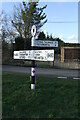
Direction Sign ? Signpost on the B480 in Cuxham with Easington parish
Located on a grass triangle in the centre of a junction on the B480 at Cuttmill Cottages in Cuxham with Easington parish. 3 arms and annulus finial.
Milestone Society National ID: OX_SU6596
Image: © John V Nicholls
Taken: 9 Mar 2008
0.01 miles
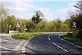
3
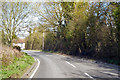
The B480
The B480 nears the Cutt Mill Junction
Image: © Shaun Ferguson
Taken: 3 May 2008
0.03 miles
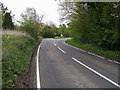
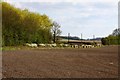
5
B480 towards Chalgrove
From the Cuxham direction.
Image: © Robin Webster
Taken: 22 Mar 2020
0.05 miles
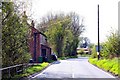
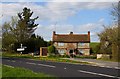
10
Isolated house on the B480 near Cuxham
Image: © David Howard
Taken: 21 Feb 2016
0.10 miles